Saturday, July 5, 2014

Frozen Head Loop HIke

I took a day off from the kids to go for a long hike in the nearby Frozen Head State Park. The park itself doesn't allow geocaches, but there was one earthcache placed just outside the park boundary that I stopped by. I also took lots of waypoints and notes on locations so that I can create a hiking wherigo/multi cache that follows my route.

A portion of the trail I took was on the Cumberland trail, which when finished will transect Tennessee. The small white marked indicates that the Cumberland Trail will also be part of the Great Eastern Trail which will go from Alabama up to New York.

The CT marker.

The earthcache I visited dealt with this small natural arch called the March Arch.

Castle Rock is one of the cool geologic formations along the Bird Mountain trail. The trail skirts around rock buttresses for about half a mile.

Sasha was my trusty companion for this hike. She handles Tennessee trails much better than New Mexico ones, keepinging up the entire day without lagging and without tearing up her pads.

At one of the backcountry campsites I found these recently used homemade camp utensils all neatly arranged on the table.

I almost stepped on this really cool Box Turtle. It was all shut up against me, the predator. And it was right to do so since I picked it up and gave it a good inspection. Looks just like the shell I found with the kids a few weeks ago. Way cool to stumble across a live one of these.


I find these signs funny. Watch out for Class III natural areas, those are for experts only. I can handle class II though.

Several places along the trail were massive vine swings. I hopped on this one for a little leaisurely swinging.

One of the most spectacular campsites that I passed was the Stone House campsite located pretty close to the lookout tower down a short side trail. The camp is completely underneath an overhanging rock, dripping with water. I'm not sure if I would want to camp there, it was very damp, but it was sure a cool spot to check out.

While most of my hike was along the ridge-top, the thick forest prevented any grand views. I bet you could get some great views in the winter when the leaves have fallen, but for my hike I had to satisfy myself with fleeting glimpses of mountains and valleys beyond. In order to get a proper view, you need to climb up the ~80ft tall observation tower, and even then the trees blocked the view to the west where the Frozen Head valley is located. Still, from the tower I could clearly see Bull Run steam plant near our house.


Just underneath the lookout tower is the wonderfully refreshing Tub Spring. I had brought my water purifier with me and pumped water here to refill my water bottles. You might be able to drink directly from this spring, it looks pretty darn clean. But better safe than sorry.

A huge polypore fungus along the trail.

We saw a pretty good amount of wildlife on our trek, including two turkeys, several white-tailed deer and a box turtle. Along one portion of seldom used trail I came across this bear track as well.

I had several options to make my hike shorter, but in the end I opted for one of the longest possible loop hikes up Bird Mtn Trail, along the Lookout Tower trail and down via Chimney Top Trail.

Amazing that anyone would construct a cement chimney way up this mountain ridge. Although there were signs of old logging roads and such in this range, so it's not that far-out. This old ruin was pretty cool.

Another rare view was had on top of Chimney Top peak, looking down over the valley towards Wartburg.

Had a few raptors flyby overhead while on Chimney Top. I wasn't sure what they were but snapped a few pictures. Turns out they were common Black Vultures.

I really liked the layers on this rest rock halfway down the Chimney Top trail. You can count the individual layers.


The end of the hike.
The hike clocked in at 17.4 miles, definitely one of my longer hikes, but it didn't feel too strenuous. most of the ridge-top hiking was long relatively flat wide trail. It was cool (high 70s), no bad weather. We cruised all day long. Still, for most hikers this route would be more enjoyable as a 2 or 3 day backpack.

Saturday, June 28, 2014

One of Eastern Tennessee's most storied caches Geo Mojo #14!


One of this areas most loved caches is Geo Mojo #14 / / National Treasure, which is a 5-star difficulty cache in an abandoned train tunnel. Levin and Sasha were brave enough to accompany me on a rainy, foggy morning. The tunnel is roughly half a mile long with the cache somewhere near the middle, but without GPS reception you have to rely on measuring the distance you've walked, in the dark, through the mud... and hope that you end up in the right spot. Or you simply just search the entire length of the tunnel. I chose the latter on our first pass, and despite finding lots of interesting hiding spots, we did not find the cache. ON our return trip, I counted off our paces 1, 2, 3, 4.... 147, 148, 149... 298, 299, 300! I decided that 300 paces was about where we should start looking carefully. The mist was making it tough to search though since it reflected our flashlights' beams.
Typical view in the tunnel
We definitely might have passed by without finding it, it is given the most difficult rating for a reason. But something a little odd caught my eye... and sure enough, on closer inspection we had found this devilishly hidden cache! Now I am a little hesitant to post spoilers, but there already are some spoilers on the cache page, so I'm going to share some pics as well. If you do not wish to see the spoilers SCROLL NO FURTHER!


SPOILER ALERT 


SPOILER PICTURES COMING UP SOON


DON'T LOOK IF YOU PLAN ON VISITING THIS CACHE, IT IS BEST EXPERIENCED WITHOUT SPOILERS


I WARNED YOU, NOW HERE THEY COME!


The cache is insidiously camouflaged with mud on the wall so it blends in almost perfectly. I was previously looking for hiding holes, or cracks, and if it wasn't for the slight crack at the top, I may not have taken a closer look and revealed this cache.


Evil indeed

How it slides out
Success!

Looting the cache


Happy Dance
We traded trackables and I left a new headlamp in the cache, and cleaned out some of the geo-junk that people leave for swag. I cache like this one deserves good stuff!

Sunday, June 22, 2014

House Mountain Dayhike


Back in New Mexico, I was used to going off on my own for serious caching adventures. The kinds of hikes not suitable for the kids (or even the dog). Rugged back-country, rocky peaks, exhausting days, that kind of thing. I love that kind of caching. Well today was my first chance to have one of these days. Liz agreed to watch the kids for the day allowing Sasha and I the day to explore. I selected a relatively modest goal, House Mountain Natural Area just north of Knoxville. Maybe only 5 miles of trails, and as many geocaches, with less than 1000ft elevation gain. But considering I am still new to the area and am not sure how hard to push myself, this seemed like a good start. It also boasts the oldest still active cache in Knox County, Penguin's Roost, which is also pretty worthy. We got a nice early start and were on the trails around 9am. We had dense cloud cover and fog, even a smattering of rain, but that only served to keep the hiking cool. I knocked off the first few caches easily enough (well, using the hints). Finding caches in dense tree cover still gives me fits sometimes, even regular sized caches. I need to develop a better woodsy geosense I guess. At the top of the ridge, there were cool sandstone rock outcrops, but the clouds blocked any views of the valleys below. The hiking along the ridge was a snap, and I passed several other hiking parties and dogs. When I reached the far side of the ridge, the clouds were starting to lift or burn off and I caught a glimpse of the valley below. I ended up scoring almost all the caches in the park, which were all ammo cans or equivalent and loaded with good stuff. The aforementioned Penguin's Roost cache even had a replacement ammo can right in front of the old container which was in perfect shape. Odd... I only missed one of the park's caches on the descent, and was back at the car a little after 1pm. Not really a full day hike, but a satisfying day none the less, and not something I could have done with the two kids. Hopefully I'll have many more opportunities to explore the wilds of Tennessee.


Friday, June 20, 2014

Bike Caching and the Chariot of Finding

Those grumpy faces were because they didn't like the helmets... at first.
For today's Daddy Day School, I decided to take the kids down to Melton Lake Park and rent a bicycle. I had saw a bike for rent with a tow-behind chariot and thought the kids would enjoy being pedaled down the trails while I could get some good exercise. Of course, we had to have some geocaches to motivate us. The tow behind bike was fun, but in rather rough shape. They only had one bike with the trailer attached, and it didn't fit me well. Plus, after the first hill I found out the right pedal was breaking off. But it was still fun. The kids would shout "Go Daddy Go" as I huffed up the hills, and would scream like a roller-coaster ride as we zoomed down the other sides. Unfortunately, most the geocaches along the biking trail are micros and the kids weren't that into them, but we had fun nonetheless, and I scored a number of finds as well.


Watching carp in the river below

Friday, June 6, 2014

A nice geocoin happenstance

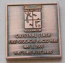
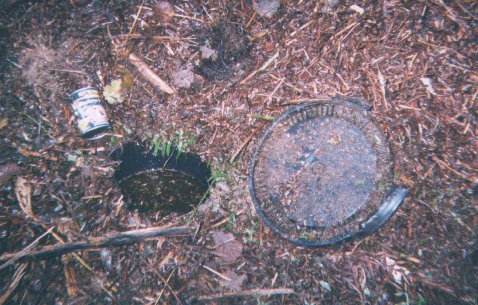
A cool thing happened with one of my geocoins. The coin commemorates the Original Stash which is the first geocache placed. Well who would have imagined, but it ends up visiting that location!
My Coin
What the Original Stash once looked like
Tribute plaque at location
Super cool!!

Thursday, June 5, 2014

Waterfalls

The kids and I visited three waterfalls today. None of them huge, but all of them fun. Only the first one had a geocache at it, Middle Fork Falls. The other two were in Frozen Head State Park, which didn't have any caches in it. Makes me wonder if caching is allowed there. We had a wonderful hike though, with the trail all too ourselves. Tennessee seems to have a wealth of waterfalls. Right now I am finding them via geocaches, but some internet searches show that there are waterfall guidebooks that show much much more. Might be worth an investment, they sure are fun to discover.
Middle Fork Falls

DeBord Falls (FHSP)

DeBord Falls

DeBord Falls

Picnic stop at Emory Gap Falls

Emory Gap Falls

Emory Gaps Falls

Wednesday, June 4, 2014

A World of Ticks


One aspect of being outdoors that we never had to watch out for while living in Southern NM is ticks. They just don't have them there. Sure they have a bunch of other dangerous plants and animals to watch out for, the ones that usually get the limelight being cactus and rattlesnakes. But these have never bothered me ll that much. But as soon as we arrived in Tennessee, we started seeing, and getting bitten by, ticks. If it was just a little bite, leaving nothing worse than an itchy spot, I wouldn't care so much about ticks. Gross as they are, they wouldn't be cause for much worry. But as carriers of Lyme disease, they've got us pretty concerned.

I don't remember being overly concerned about ticks growing up in New Hampshire. In fact, I barely recall ever seeing them, except maybe on our dog. Lyme disease is pretty nasty, often with long term chronic problems, but since we weren't getting ticks, it wasn't forefront in our minds. It's a different story here in Tennessee, where it seems that every time we go for a walk in the woods, whether on trail or not, we end up with ticks crawling on our clothing. Levin had one bite him on his back our first week here, a tiny nymph stage tick, the worst one's as far as Lyme disease is concerned. I got one on my leg only a few days later, and two more bites in places I'd rather not mention on the blog a few weeks later. Since my dad was here for those first few bites, he got us a prescription of antibiotics as a preventative measure against Lyme disease, and Levin and I both took our doses. He's sending us more soon, and I suspect we'll gobble it up like candy.

As if to make matters even worse, one of the species of ticks here, the Lone Star Tick, has a relatively new disease it can pass on, the Heartland Virus Disease. This is one of the tick species that is actually pretty easy to identify and I was almost reassured by noting that some of the ticks we were getting were these ones. But if I was assured that the Lone Star Tick doesn't carry Lyme Disease, I need to be worried about another new, and potentially fatal disease as well.
For now it's a matter of being extra vigilant. Pretty much all the geocaches I am interested in going after are in tick infested forests. I've never payed attention to the geocaching.com tick attribute,  before but I sure will now. And tick checks when we get home are routine. All part of learning to live, and geocache, in a new area.