
Sunday, July 27, 2014
Geohash Collision
It's been a while since I thought about geohashing, but for some unknown reason, I found myself checking out the local geohash locations on peeron maps. The geohash was in an interesting spot, but not worth a trip. But just the act of checking the lcoation gave me the itch, and I found myself checking the site throughout the week, wondering if there would be a geohash nearby that I could stop by at. We actually live in a really great spot for geohashing, right at the corner of 4 graticules, so that if the geohash is close to any one corner, it is a reasonable distance to get to. Well, today there was a convenient geohash just down the road from us in Oliver Springs, and to make things sweeter, there was also a geocache collision there. So Levin and I hopped in the car, under the auspices of doing errands, and putted over to grab the geocache and geohash. The geocache, GC3EKBM, was 650m from the geohash location (36.0440391, -84.3360050) which was only ten feet off the road in some Kudzu vines. I snapped a cheesy selfie of myself at the location with my Nexus (camera was without memory card again!) and off we went to actually do some errands. Nice little diversion from the usual geocaching thing.
Monday, July 21, 2014
A Wherigo Tramp through Frozen Head SP
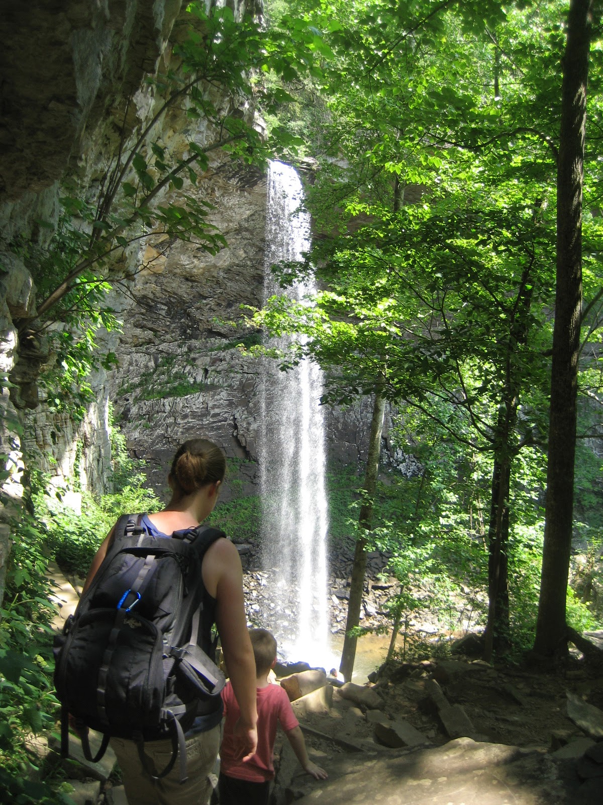
Woohoo! My very first Wherigo cache has been published, Ridge Hiking in Frozen Head State Park. When I first visited the park with the kids a few months ago, I though it was odd that there weren't any caches there. It is such a great natural area, with tons of trails, historic structures, waterfalls, mountain views and wildlife. So I posted a question on Facebook and got a response from the locals that the Manager for the park does not want geocaches placed there, not even virtual Earthcaches. Still, after doing some more hiking in the park, I got to thinking about ways I could set up a cache that visits the park, but has a container just outside of it. At first I was thinking of making it a Multi, but doing so inevitably means having to make-up some method for people to determine the final coordinates during their hike, and there is always room for ambiguity, and frustration on these types of multis (although I usually quite enjoy them myself). If only there was some way to ensure folks have to go on a good long hike, but not have to mess with silly questions about numbers on signs, and counting stairs and such...
A little while later the kids and I completed one of the two local Wherigo caches, which was a really well put together adventure on a little park south of Knoxville. The light-bulb went on in my head, I could do a really simple Wherigo tour in Frozen Head! All you would have to do is hike from point to point to complete the cartridge. Sure I would give some information about each point, make it a tour-guide kind of thing, but one wouldn't have to bother with any annoying questions, silly arithmetic or frustration of not getting to the final because of a bad interpretation. It seemed like the perfect solution. Although admittedly, you do have to have some extra technological know-how to complete a Wherigo. I've only just started to be able to do them since acquiring a Nexus 7 tablet. Most people with Smartphones can do them though, so I figured the technological hurdle isn't too high.
Actually building the Wherio was not too hard, since I used a convenient website Wherigo\\kit. I used the "Tour guide" template and whipped together a 16 stage tour of a long hike in the park. Once it was complete, I compiled the cartridge and loaded it to my Nexus. I made a trip out to the area last week to hide the final container (outside of the State Park boundaries), and did a test run of the first two locations of the cartridge. They worked perfectly! After putting some final touches on the cartridge, I published the Wherio on the www.wherigo.com site, and then put together my geocaching.com listing. After all the effort it took to put together, I still wasn;t even sure if a volunteer reviewer would publish it to geocaching.com. Days passed, nothing happened. But today I got a notification that it was published.
So now I invite all those hikers and lovers of nature, come try out this Wherio. The hike is long but rewarding. The park is beautiful. The geocache is well, a plastic container hidden in the woods filled with trinkets. Yep, pure geocaching glory awaits you. Enjoy some random pics from my hike.


A little while later the kids and I completed one of the two local Wherigo caches, which was a really well put together adventure on a little park south of Knoxville. The light-bulb went on in my head, I could do a really simple Wherigo tour in Frozen Head! All you would have to do is hike from point to point to complete the cartridge. Sure I would give some information about each point, make it a tour-guide kind of thing, but one wouldn't have to bother with any annoying questions, silly arithmetic or frustration of not getting to the final because of a bad interpretation. It seemed like the perfect solution. Although admittedly, you do have to have some extra technological know-how to complete a Wherigo. I've only just started to be able to do them since acquiring a Nexus 7 tablet. Most people with Smartphones can do them though, so I figured the technological hurdle isn't too high.
So now I invite all those hikers and lovers of nature, come try out this Wherio. The hike is long but rewarding. The park is beautiful. The geocache is well, a plastic container hidden in the woods filled with trinkets. Yep, pure geocaching glory awaits you. Enjoy some random pics from my hike.
Thursday, July 17, 2014
LaMance and Potter Falls
I took the kids for an afternoon adventure to two really great waterfalls about 45 minutes away from our house. The first, LaMance Falls, was a half mile hike up the Crooked Fork of Emory River. There were little bits of trail here and there, but the going was mostly just over the riverbed, or bushwhacking along the riverbanks. Ada got carried, but Levin got to rough it, hopping over rocks with me up the river. Pretty slow going, but fun too. The river was more like a small stream, but evidence that is gets much higher was all over; broken limbs and trees up on the banks, empty bottles and other trash strewn about 4ft up the sides of the river. I bet this river really rages, but today it was mellow and easy to travel up. It was also a little bit stinky, either fishy or rotting algae smell, I'm not sure which. The falls and monolith eventually came into view, an excellent reward for our efforts.


 After finding the geocache there, GC15F2F, and having a nice snack, we started back along a different route. On the western bank there is an old carriage trail. I was hoping it would lead us back to the car, so we followed it. For some of the "road" it was easy going, but large fallen trees impeded progress. We popped out on a road about a mile away (not as the crow flies) from where we had parked. We could have tried to go directly back to the car through 1/4 mile of forest and brush, but instead opted for the road walk. Somewhere along the carriage road, I got covered in ticks, the little poppy-seed-sized ones. I must have flicked a dozen off of my pants, and a hand-full of of Levin too. Hiking along the road seemed better for avoiding the ticks.
The car was parked at another waterfall, Potters Falls, which has an Earthcache I wanted to log. It was only a short walk to the upper Potter Falls. We were about to have a snack right there, but instead we decided to explore a little further where we found an excellent spot at the Lower Falls. Ada spotted a snake swimming in the water after a school of sunfish. I think it managed to grab one before swimming back to the rocky shore. If it weren't for the snake, this would be an awesome place to swim and play. Maybe another time.


One negative about being so close to the road is the area is full of trash, beer cans mostly, but lots of other trash as well. I am already thinking about organizing a CITO here to clean it up, and play in the water.
 |
| The monolith to the left is about 20ft tall, and had a knotted rope attached to its top. Looks like a fun place for water-play. |
The car was parked at another waterfall, Potters Falls, which has an Earthcache I wanted to log. It was only a short walk to the upper Potter Falls. We were about to have a snack right there, but instead we decided to explore a little further where we found an excellent spot at the Lower Falls. Ada spotted a snake swimming in the water after a school of sunfish. I think it managed to grab one before swimming back to the rocky shore. If it weren't for the snake, this would be an awesome place to swim and play. Maybe another time.
 |
| Upper Falls |
 |
| Lower Falls |
One negative about being so close to the road is the area is full of trash, beer cans mostly, but lots of other trash as well. I am already thinking about organizing a CITO here to clean it up, and play in the water.
Thursday, July 10, 2014
Some recent Stellar Caches
One of the minor pitfalls of finding really cool caches is that it is difficult to share details about them without giving away the fun. In the past few weeks the kids and I have found a couple really awesome caches. I think I can share a little bit about them without giving away where they were, or which geocaches I might be spoiling. And to be honest, I'm not sure any of the local Tennessee Valley Geocachers (TVG for short) are following my blog, so the risk is small.
 |
| This well camouflaged PVC container contains a home-made Cryptex |
 |
| Ada shows the Cryptex |
 |
| ...and the inner container revealed |

 |
| Container is taller than Levin. |
 |
| Contents of the munition tube |
These two caches are definitely highlights of the area, and ones that I found unique, or at least haven't seen before.
Sunday, July 6, 2014
Black Mountain and Ozone Falls
One of the other Post-Docs at NMBios has kids that are Levin and Adas ages. They also really like going on hikes and exploring the area, so it seemed only natural that we should meet up for some exploration and playing. I suggested Black Mountain as our primary destination, an area I've had my eye on visiting since it supposedly has an easy loop hike, great rock formations (and even rock climbing) scenic views and of course, geocaches.


As you can see from the pictures below, the area lived up to my expectations.
The kids hit it off, and were soon running around, jumping on rocks, yelling, playing hide and seek, just having a great time. We had a leisurely picnic and I even got a chance to put on my climbing shoes and do a few bouldering problems. On the hike back to the car, we stopped at a geocache, GC2524, one of the older ones in the county and I hoped that it would have really neat kid toys in it so that we could show the other family how cool geocaching is.
Turns out the cache was mostly filled with junk, even melting gross M&Ms. Kind of a disappointment for such a nice cache container in a great area. I cleaned out most of the garbage, and we left a new toy in the cache. I think the the other family still might enjoy geocaching, but I wish the cache had been in better shape.
Instead of just heading home after our hike, I suggested we stop at Ozone Falls, which was nearby and shouldn't take long to see. Yes, of course there is an Earthcache there, but it was also becoming a hot afternoon and I thought that we might want to take a little dip to cool off. The falls were amazing, a 110 ft plunge into a large pool. We all stripped down and got in the water, cooling off, and enjoying the novelty of swimming underneath the falling water. A great finish to a great day.
All in all, 3 earthcaches logged and 2 traditionals, but more importantly, a great family outing to an area I hope to return to.
Saturday, July 5, 2014
Frozen Head Loop HIke
I took a day off from the kids to go for a long hike in the nearby Frozen Head State Park. The park itself doesn't allow geocaches, but there was one earthcache placed just outside the park boundary that I stopped by. I also took lots of waypoints and notes on locations so that I can create a hiking wherigo/multi cache that follows my route.

A portion of the trail I took was on the Cumberland trail, which when finished will transect Tennessee. The small white marked indicates that the Cumberland Trail will also be part of the Great Eastern Trail which will go from Alabama up to New York.

The CT marker.

The earthcache I visited dealt with this small natural arch called the March Arch.

Castle Rock is one of the cool geologic formations along the Bird Mountain trail. The trail skirts around rock buttresses for about half a mile.

Sasha was my trusty companion for this hike. She handles Tennessee trails much better than New Mexico ones, keepinging up the entire day without lagging and without tearing up her pads.

At one of the backcountry campsites I found these recently used homemade camp utensils all neatly arranged on the table.

I almost stepped on this really cool Box Turtle. It was all shut up against me, the predator. And it was right to do so since I picked it up and gave it a good inspection. Looks just like the shell I found with the kids a few weeks ago. Way cool to stumble across a live one of these.


I find these signs funny. Watch out for Class III natural areas, those are for experts only. I can handle class II though.
Several places along the trail were massive vine swings. I hopped on this one for a little leaisurely swinging.

One of the most spectacular campsites that I passed was the Stone House campsite located pretty close to the lookout tower down a short side trail. The camp is completely underneath an overhanging rock, dripping with water. I'm not sure if I would want to camp there, it was very damp, but it was sure a cool spot to check out.
While most of my hike was along the ridge-top, the thick forest prevented any grand views. I bet you could get some great views in the winter when the leaves have fallen, but for my hike I had to satisfy myself with fleeting glimpses of mountains and valleys beyond. In order to get a proper view, you need to climb up the ~80ft tall observation tower, and even then the trees blocked the view to the west where the Frozen Head valley is located. Still, from the tower I could clearly see Bull Run steam plant near our house.


Just underneath the lookout tower is the wonderfully refreshing Tub Spring. I had brought my water purifier with me and pumped water here to refill my water bottles. You might be able to drink directly from this spring, it looks pretty darn clean. But better safe than sorry.
A huge polypore fungus along the trail.

We saw a pretty good amount of wildlife on our trek, including two turkeys, several white-tailed deer and a box turtle. Along one portion of seldom used trail I came across this bear track as well.

I had several options to make my hike shorter, but in the end I opted for one of the longest possible loop hikes up Bird Mtn Trail, along the Lookout Tower trail and down via Chimney Top Trail.

Amazing that anyone would construct a cement chimney way up this mountain ridge. Although there were signs of old logging roads and such in this range, so it's not that far-out. This old ruin was pretty cool.

Another rare view was had on top of Chimney Top peak, looking down over the valley towards Wartburg.

Had a few raptors flyby overhead while on Chimney Top. I wasn't sure what they were but snapped a few pictures. Turns out they were common Black Vultures.

I really liked the layers on this rest rock halfway down the Chimney Top trail. You can count the individual layers.

The end of the hike.
The hike clocked in at 17.4 miles, definitely one of my longer hikes, but it didn't feel too strenuous. most of the ridge-top hiking was long relatively flat wide trail. It was cool (high 70s), no bad weather. We cruised all day long. Still, for most hikers this route would be more enjoyable as a 2 or 3 day backpack.
Subscribe to:
Posts (Atom)