Friday, June 20, 2014

Bike Caching and the Chariot of Finding

Those grumpy faces were because they didn't like the helmets... at first.
For today's Daddy Day School, I decided to take the kids down to Melton Lake Park and rent a bicycle. I had saw a bike for rent with a tow-behind chariot and thought the kids would enjoy being pedaled down the trails while I could get some good exercise. Of course, we had to have some geocaches to motivate us. The tow behind bike was fun, but in rather rough shape. They only had one bike with the trailer attached, and it didn't fit me well. Plus, after the first hill I found out the right pedal was breaking off. But it was still fun. The kids would shout "Go Daddy Go" as I huffed up the hills, and would scream like a roller-coaster ride as we zoomed down the other sides. Unfortunately, most the geocaches along the biking trail are micros and the kids weren't that into them, but we had fun nonetheless, and I scored a number of finds as well.


Watching carp in the river below

Friday, June 6, 2014

A nice geocoin happenstance

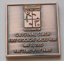
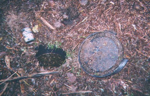
A cool thing happened with one of my geocoins. The coin commemorates the Original Stash which is the first geocache placed. Well who would have imagined, but it ends up visiting that location!
My Coin
What the Original Stash once looked like
Tribute plaque at location
Super cool!!

Thursday, June 5, 2014

Waterfalls

The kids and I visited three waterfalls today. None of them huge, but all of them fun. Only the first one had a geocache at it, Middle Fork Falls. The other two were in Frozen Head State Park, which didn't have any caches in it. Makes me wonder if caching is allowed there. We had a wonderful hike though, with the trail all too ourselves. Tennessee seems to have a wealth of waterfalls. Right now I am finding them via geocaches, but some internet searches show that there are waterfall guidebooks that show much much more. Might be worth an investment, they sure are fun to discover.
Middle Fork Falls

DeBord Falls (FHSP)

DeBord Falls

DeBord Falls

Picnic stop at Emory Gap Falls

Emory Gap Falls

Emory Gaps Falls

Wednesday, June 4, 2014

A World of Ticks


One aspect of being outdoors that we never had to watch out for while living in Southern NM is ticks. They just don't have them there. Sure they have a bunch of other dangerous plants and animals to watch out for, the ones that usually get the limelight being cactus and rattlesnakes. But these have never bothered me ll that much. But as soon as we arrived in Tennessee, we started seeing, and getting bitten by, ticks. If it was just a little bite, leaving nothing worse than an itchy spot, I wouldn't care so much about ticks. Gross as they are, they wouldn't be cause for much worry. But as carriers of Lyme disease, they've got us pretty concerned.

I don't remember being overly concerned about ticks growing up in New Hampshire. In fact, I barely recall ever seeing them, except maybe on our dog. Lyme disease is pretty nasty, often with long term chronic problems, but since we weren't getting ticks, it wasn't forefront in our minds. It's a different story here in Tennessee, where it seems that every time we go for a walk in the woods, whether on trail or not, we end up with ticks crawling on our clothing. Levin had one bite him on his back our first week here, a tiny nymph stage tick, the worst one's as far as Lyme disease is concerned. I got one on my leg only a few days later, and two more bites in places I'd rather not mention on the blog a few weeks later. Since my dad was here for those first few bites, he got us a prescription of antibiotics as a preventative measure against Lyme disease, and Levin and I both took our doses. He's sending us more soon, and I suspect we'll gobble it up like candy.

As if to make matters even worse, one of the species of ticks here, the Lone Star Tick, has a relatively new disease it can pass on, the Heartland Virus Disease. This is one of the tick species that is actually pretty easy to identify and I was almost reassured by noting that some of the ticks we were getting were these ones. But if I was assured that the Lone Star Tick doesn't carry Lyme Disease, I need to be worried about another new, and potentially fatal disease as well.
For now it's a matter of being extra vigilant. Pretty much all the geocaches I am interested in going after are in tick infested forests. I've never payed attention to the geocaching.com tick attribute,  before but I sure will now. And tick checks when we get home are routine. All part of learning to live, and geocache, in a new area.

Wednesday, May 28, 2014

Caching with a Nexus 7

See that little green book I'm holding? That's my new Nexus 7. Well, not new really, it was given to em by my mom's boyfriend who was trying to get rid of it or maybe just trying to make a good impression. He didn't have to give me a tablet to do that though, but I am liking have this handy little device. What do I use it for? Well, email and internet sure... but where I really see it's potential is for geocaching. My primary geocaching device up until now has been my trusty Garmin GPSmap 60CSx. This device has served me well, with topo maps that I download for free, and a nice sized screen to navigate with on those maps. It is limited to only 1000 waypoints, and though there are ways I could import more using POIs, I never have bothered to figure that out. What I bemoan about this device is the lack of geocaching beta. All those waypoints I have in it are "dumb", they contain the name of the cache but little other data. No cache size, D/T ratings, recent logs... Sometimes, geocaching like this gives me a sense of elitism. "Ha, I don't need to know anything about the cache, just the coords, the way caching used to be. The way it is best." More often than not though, I end up phoning home to ask my wife to go online to give me the beta, and hints. What would be ideal would be to have a cellular connected device running geocaching aps, where I could always instantly pull info on caches. The Nexus 7 I have is not that. But it does have a GPS antenna, can run geocaching aps, can store loads of pocket queries complete with all the usual cache information. It can do a lot of what the "paperless caching" GPSr devices do. Just no cellular connection. A step up?

After a little bit of trial with C:geo, I end up going with Locus Pro for a map and geocaching app. I get a chance to try it out a little in Las Cruces, using it to search for a few caches with Levin. While the map and cache selection work great, the compass feature steers me way off. I fiddle with the settings for a bit, switching the "hardware compass" on and off. But it never seems to work well for getting me right to GZ. The arrow almost never points in the correct direction and I end up just walking in whatever direction seems to decrease my distance metric the fastest. Not optimal at all. BUt I'm still learning, maybe there's a trick to it?

The Nexus becomes my primary caching device for our trip from Las Cruces to Knoxville since I didn't bother to download maps or PQs into my Garmin. For traveling along the road it works fine, but I still have a hard time navigating to GZ. But it definitely shines when it comes to browsing a bunch of cache sin an unknown area and deciding if any of them are worth going after. It still lacks some features that I would like to have, number of favorite points for instance. maybe I'll break down and learn GSAK one of these days and get its companion app, but until then I think this will do.

One feature I like but have not fully gotten used to is the offline field notes. I am still terrible at typing out a sentence let alone a paragraph on the Nexus, but once I can manage that, I will be able to write logs in the field and have them synced online when I have connectivity. For now taking brief notes about the cache and fleshing out the logs at home is still my preference, but I can see using this feature more and more, especially for any power caching type trips. And the voice dictation feature provided by the Android OS is very tempting to sue as well, but so far my attempts to use it have been rather hilarious.

Durability and battery life though will never come close to the Garmin. So for most of my hikes, the Garmin will be my main device. Still,. it will be great to have the Nexus along in the pack, for some extra beta when needed.

Friday, May 16, 2014

My Knoxville geocaching inauguration

For my inaugural Knoxville geocaches, I went for a run in IC King park, which was pretty close to where we were staying. We hadn't hit up any geocaches for our first several days in town, we were too busy with finding housing. But once we had a lease agreement signed, I was eager to see what the caching is like here. It was a weekday morning and I had the trails to myself. Well, the dog and I had the trails to ourselves. I was particularly worried about getting posion ivy, but not enough where I wouldn't go after the caches. I started with GCJAJ7 and ended up stopping at 10 caches for my ~5 mile run. Almost all of the caches were pretty far off the trail, and through, what looked to me, patches of poison ivy. But maybe I just don't know my plants yet. The ones I found were good, large and old geocaches. Most dating back to 2004. Cool to see an area where 10 year old caches are not that rare. There is definitely a long standing geocaching community here. I ended my run at GCJD4X, where I failed to turn up the cache, but did find a dead snake. At first I thought it was a fake dead plastic snake and the cacher's were being clever. Nope, real dead snake! No shame calling a DNF on that one!

Wednesday, May 14, 2014

Caching our way to Knoxville

Moving to Tennessee was a lot of work. First there was all the work getting our house ready to go on the market, then packing up stuff, arranging moving our stuff, figuring out what route to take. Geocaching played only a minor role in this process. A welcome relief from the stress while packing up. But more practically, a helpful guide for where we might stop along our route. The route was planned around having decent places to camp in parts of the country we've never seen before. I used a series of PQs to look for interesting caches, and therefore interesting places along this route. But the goal was to move to Knoxville, not find a gazillion caches or even interesting caches. In fact, for the whole 4 day trip, we only stopped at 9 caches, half of which were virtual or earthcaches. But the stops were all memorable, and indeed, the caching provided good entertainment.

Day 1

We left Las Cruces, NM and headed North-East, through Alamogordo and Carizozo and up to Santa Rosa, where we made our first stop at the Blue Hole. Not only is this a fantastic spot to take a dip, but the surrounding parks were ideal for a picnic and playing around. 

 After being refreshed by the bright blue waters of Santa Rosa, we zoomed East to Amarillo where we made a stop at the famed Cadillac Ranch. This is actually one of the stops that I found as a result of my PQs, since this Virtual Cache has racked up a ton of favorite points, and just looks like an awesome spot to stop by for a visit while traveling I-40. We didn't stay long though because we needed to make it to our camping destination at Palo Duro Canyon state park.

 Day 2

Despite Palo Duro Canyon ahving hundreds of caches, I did not have any loaded into my GPSr or Nexus before the trip started, so I didn't log any finds there. What, enjoying a beeautiful camp site and park without finding a geocache?! Funny how I link logging a cache to enjoying a location now, but I do find myself thinking that sometimes. It really is an awesome park, and it was a shame we didn't have time for a hike.

 Driving east along I-40 through the Texas panhandle and Oklahoma was windy. And not a nice tail-wind I was hoping for, but a cross wind that buffeted the cars all day long. I bet folks are used to that in these parts.
 We needed a lunch stop in Oklahoma and looking for a nearby geocache once again paid off, but not in the way I imagined. We pull off the highway in the little town of El Reno, and head to a cache a little off the highway near a State Historic site. We stop for this first cache, GC36G4Q, but it is way too windy to have the picnic we were planning. However, we are right at the entrance to the State Historic site, so we head over there to see if we can find some shelter. I run into the visitor center and ask the woman there if there is a sheltered spot for us to have a picnic, and she invites us to use the basement of the Fort's Chapel. And wouldn't you know, there happens to be a geocache in that same building! GCGFD5 is actually in the chapel, and is one of the older geocaches I've found, dating back to 2003. We had the place pretty much to ourselves, and had a splendid picnic out of the wind


We make campe in eastern Oklahoma at Lake Eufalah state park, but only because the winds had died down by the evening. Despite there being caches enar our camping spot, we don't go looking for them. Our camp by the lake is all the entertainment we need.

Day 3

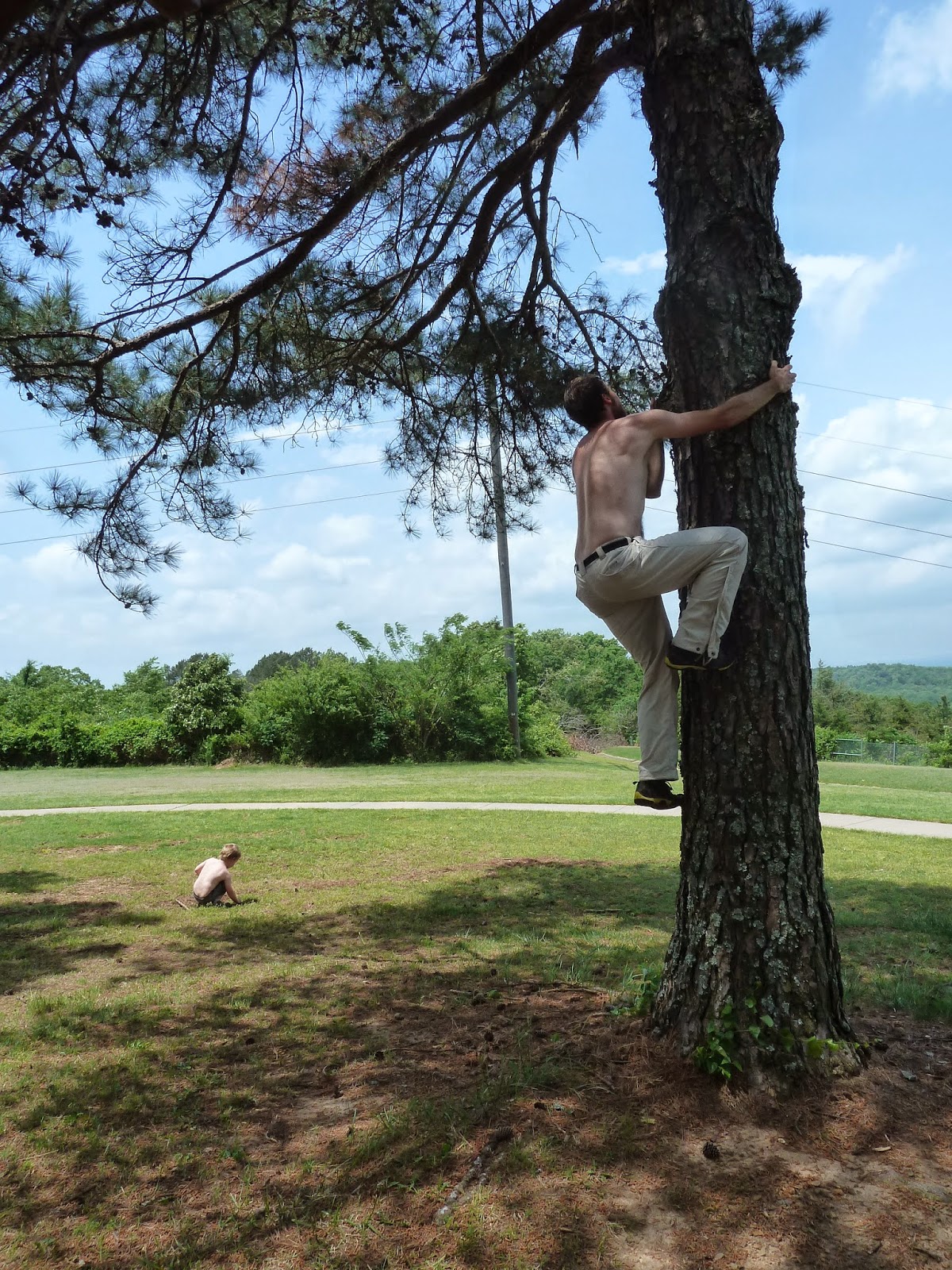
We quickly cross into Arkansas and begin our traverse of that state. But not an hour into the state the kids are whining up a storm, so we pull off at an exit. I whip out the Nexus and take a look and sure enough, there is a convenient geocache in a travel stop just a mile ahead, so we drive over to discover one of the most relaxing travel stops I've ever visited. The geocache I had in my device, Hillbilly Hotel, was at the far western corner of the rest area, which we had all to ourselves. A big grassy field, picnic tables under mature pines, a view of the Ozark mountains to the north, and my personal favorite, cool clean ozark water from lovely brass spigots. Most delicious water I've tasted in a while. Levin and I run over to find the cache right away, and unfortunately it is almost empty, not even having any travel bugs. But it did have one toy, a plastic boomerang. We traded something for that, and then commenced playing with it in the field. Predictably, the boomerang was soon stuck 25ft up in one of the pines. We spent the next 30 minutes working on getting it down. Every time I was about to call it quits, Levin would make the saddest faces and I would try just "one more thing"

Failed attempt to throw a rope up to grapple the branch.

Failed attempt to climb tree

What are we doing here? Somehow we all lost our shirts, something about the hot humidity.... Or maybe we're jsut trying to be hillbillies.

Success! Using this large branch taken from near the cache site.
 The long break did the trick, and we breezed through the rest of Arkansas and into Tennessee.

Day 4

Our last day turned out to be our most relaxing one, with the least amount of miles needed to reach Knoxville. We camped at Natchez Trace State park, which had incredible facilities (but expensive fees for camping!). We had a leisurely morning walking some trails and doing some birding, and finding my first Tennessee geocache, Cub Lake Waterfront. The tulip poplars were in bloom and the woods were gorgeous. Living in NM for so long, I'm not used to such lush growth, and we were all drinking it in.
 We drive a few more hours and make a lunch stop at another state park a little further away from I-40 but well worth the trip, Burgess Falls. Once again, I didn't have any geoaches for this park in my devices, but I was able to qualify for an earthcache by being observant, taking a bunch of pictures and doing a little online reading.
And that's my travel-caching experience. On the one hand, it didn't feel like a lot of caching, but geocaching did play an important role in where we stopped, and how we broke up the difficult drive east. With two young kids, a dog and 5 birds with us in the cars, having good places to stop, and making frequent stops is key. More time would have been better though, to really enjoy some of the state's we passed through... and find a few more caches ;).