Sunday, October 29, 2017

Not one of my better ideas

 The weekend comes and there aren't any set plans or agendas for the family. So I suggest, why not a geocaching adventure hight up into the mountains to see some nice fall colors? The family agrees, we pack up a nice picnic lunch and head out for what should be a nice little drive. My target is Glorieta Peak (GC6MVDF), one of the accessible mountains near Santa Fe. I should put "accessible" in quotes though. While the Santa Fe Ski basin and Tesuque peak you can drive right up to on nice paved roads, Glorietta peak requires driving out to Pecos first, then taking old forest and logging roads for a good 12 miles. The going is SLOW. And to make matters worse, I miss a turn off on our way up, wasting even more time.

By the time we reach Glorietta peak, it is well past lunchtime and the kids are famished. We get out of the car and it is freeeeeeezing cold. Much colder than it was in town. A cold front must have been moving in as we drove up, and along with the cold temperatures, we are also socked in by clouds, unable to even get a nice view. Our outside picnic is a flop, everyone is too cold to enjoy the food. My plan to do a little hike down the ridge to Mt. Taylor and GC6MVDF, is quickly abandoned. no one is in the mood for this. Why did Dad drag us all up here again? Next time we stay home and watch movies and eat popcorn.... sigh...

One cold kid

Lovely views eh?

Sunday, October 1, 2017

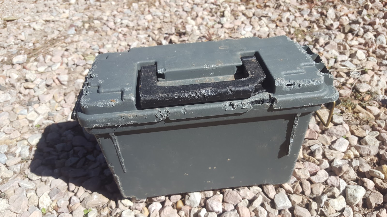
BEHOLD: THE DESTRUCTIVE POWER OF PACK RATS

 Or maybe it was a rock squirrel or some other rodent. Anyways, my nice new plastic ammo can that I used for my cache, Ear Worm, wasn't even out for 4 months when some kind of rodent successfully chewed all sorts of holes in the container. This really gets you to rethink using plastic containers out here in Santa Fe.


The final has been replaced with a metal container now. I do love checking on the Earworm Cache as I get to listen to all the fun recordings geocachers have left. Makes cache maintenance pretty fun.

Friday, September 15, 2017

Hiding a massive new Multi Cache: Winsor Trail

I've had this idea to hide a long multi cache on the Winsor Trail, outside of Santa Fe, since I first hiked some portions of it. The trail is 22.8 miles long and goes from Cowles, NM to Tesuque, NM. It crosses over a nice high mountain pass between Santa Fe Baldy and the Santa Fe Ski basin, and some of the sections of it are very popular. indeed, I first hiked a section with my family when going up to Nambe lake. Over the year I found myself on hikes doing portions of the trail, and thinking to myself, "I bet I could hike this entire trail in a day".

Well that day finally came, on one of my off-Fridays. After getting my new GPS, I needed a good long hike to test it out on and it was time to tackle the Winsor trail. My plan was fairly simple. I would drive to the Cowles trailhead very early in the morning, and hike up over the high mountain pass, and then down to Tesuque, arriving around the time my wife would be getting off work. She would then pick me up. We'd have to retrieve the car at Cowles, so to make this more fun, I stashed most of our camping gear in the car that I left up there and we would have a little fall camping trip for the weekend. It sounded like a decent plan to me....

My hike got off without a hitch. This would be my second attempt at hiding a big long multi cache and I was prepared with a nice final container, and a dozen small pre-form tubes to use as stages along the way. My first attempt didn't end that well though. After much planning and hiding, the whole cache (all 9 stages) was stolen/taken. And only five days after it was published! This one would be about the same number of stages, but a much longer hike, more than double actually.
Starting the hike near Cowles
After a couple miles of hiking I hid the final at a spot with a suitably nice view. I left an unactivatted trackable as FTF prize as well as some other nice goodies.
View near the final

Between Final and next/previous stage
 The weather was nice and cool, but there was a pretty stiff breeze. more like a howling wind at times. This kept me pretty cool, but made me worried a bit that a storm would blow in and dump on me.
Nice aspen grove near Stage 8
 My approach to this multi was to hide stages roughly 2-3 miles apart and have each stage be at a location that is significant. By significant, I was thinking a stellar view, or cool stream crossing, or neat rock formations, or beautiful meadow... basically a spot where if you were hiking the trail, you'd think to yourself 'this is a great spot to stop for a break'. At least that is what i had in mind. Some portions of the trail I hadn't been on before, so i didn't really know where the nice spots would be along these sections. And after hiking a suitable distance I often found myself wanting to place a stage where I was rather than keep going further. And a few times, I passed by locations that would have been great thinking that I needed to put a bit more distance between stages.
One of the many trail junctions. Still haven't been down the holy Ghost trail....

An old trail junction not shown on the updated trial maps, but still on some older maps. This trail would have made a nice shortcut for the first few miles of the Winsor trail. poh well.
 One of the nicest spots along the trail is Spirit lake, a remote alpine lake that is pretty deep into the Pecos Wilderness. According to literature, it is a popular backpacking destination and I can see why. There was also an unfound geocache there, GC77WWW, which I was keen on grabbing the FTF on.


Stage 7 near Spirit Lake
 Stages 5 and 6 were along the very popular section of trail between the Ski basin and Santa Fe baldy junction. This portion of the trail was all pretty wooded, and there were also a fair number of existing geocaches along the trail that I had to work around, so my hides for these stages weren't all that spectacular. But what are you going to do right?

DNF on GC57YHY, my 2nd time too!

 Let's just say, this is a pretty long hike. It was later in the day than i thought it would be when I hiked into the Santa Fe Ski basin parking area. The trail actually skirts just around the parking area. I seriously considered calling my wife and having her pick me up there, and doing the rest another day. But then my determination to complete the whole hike set in. The rest was downhill afterall, should be a piece of cake right? But also... hmm.. are those rain clouds moving in?
I found this sign amusing, and might have to come up with a geocache hide around it....
 There were some cool spots that I should have hid stage 4 at, but I had passed them by and then ended up hiding stage 4 in a rather lame spot. It is even near an access road making it easy to get if someone were breaking up the stages into separate hikes. Again, all I could do was shrug this off. I have no way of knowing how geocachers will actually tackle this cache.
Huge stick fort dounf along the trail
Stage 3 was in a slightly better spot, near a rock outcropping and just out of siight from the main trail. I saw a few mountain bikers down this way, doing the Borrego trail loop maybe? There were also another geocache for me to find down here, which I happily made a small detour to get.
Getting very tired... junction near Borrego trail
 On the down side, it started to rain a little and I was getting quite sore and chaffed from all the miles. At the Chamisal junction, I still had 3-1/2 miles to go, but I was wipe.
Chamisal trail junction... almost done
 The sun was setting as I reached the Tesuque trailhead and called my wife to come pick me up. The final count on stages was 9, including the final. Stretched out over 22.8 miles that's about 2.5 miles per stage. A darn good multi cache if you ask me. Now... who's going to go find it?


Friday, September 8, 2017

Why not Latir today?

Latir Mesa is a remote wilderness area in the Northern part of the state that I have been eying for a hike for a year now. The main reason being... there are two very lonely, unfound geocaches high up above treeline. Why hasn't anyone bothered to visit these? Is the hike horrendous? Is the drive out simply too far to justify going after a few little geocaches? Is the mountain range not worth a visit? I had to find out for myself. And on September XX, I did.

Here is my answer to the above questions:
  1. While the hike is long, it is not horrendous at all. In fact, mostly it is on well maintained trails, and a huge portion of it is above tree-line, with scenic views all around.
  2. The drive wasn't too bad. 2.5 hours from Santa Fe, and mostly on nice highways. The last little bit up to the trailhead was a bit rough, but nothing I would call terrible.
  3. The Latir Wilderness is fantastic! Remote high peaks, great views, beautiful lakes. Sure they aren't as rocky and jagged as some stuff a bit further north in Colorado, but still... great hikign area.
Here are some pics of my hike.


Some bolete mushrooms I harvested along the trail


FTF!


Puffball mushroom on the mesa

Cabresto Lake

Oh... and I did manage to nab a FTF on both GC6MHF5 and GC6MHED. WooHoo!

Sunday, July 9, 2017

Geocaching as consolation: Zapata Lake

I can't remember if or when I have climbed a 14er before. Growing up, my family went on many trips into high mountains of the west, but my memory of exactly where we went, and how high the peaks were is hazy. Living here in Santa Fe though, suddenly puts me in striking distance to several 14ers in Colorado, and this weekend I jumped at an opportunity to climb one. One of my wife's colleagues, Uttam, wanted to summit Ellingwood Point, and hatched a plan to leave at 2 in the morning drive up, summit the peak and be down off the ridge before 12pm. I guess there was a decent chance of afternoon thunderstorms. The trip sounded pretty intense but also the kind of thing that gets me excited. I talked him out of the 2am start though, instead suggesting we leave the night before and bivy at the trailhead. He agreed to this approach.
Full moon above our bivy

We pulled into the trailhead parking around 9:30 pm and the first thing we realize after getting out of the car is that the mosquitos are out in force here. Even at 9,000ft elevation, they are present. Neither of us had any real mosquito protection, we just had a few sleeping pads and sleeping bags. Not being able to do much about it, we set up the sleeping gear and settled in for the night, only foir it to start to rain on us. Luckily, I did have a tarp big enough to go over us, and it even helped keep the mosquitos off our faces, but even so I slept pretty fitfully. It didn't help that there was a big, bright, full moon shining directly overhead.

4am, the alarms beep and we get up and make our final preparations for the hike. By 4:30 we are on the trail and headed up to Zapata lake. The full moon lights the trail pretty well, and we don't have to use headlamps to make steady progress. Up and up we go. The moon sets behind the ridge to our south, and the sky lightens. We reach Zapata lake around 7am, and the sun is just about to pop over the ridge in front of us. We are making good time so far, but the going gets tough from here on out.
Zapata Lake


There is couloir called C2, which is the most efficient way to scale Ellingwood peak, but it is still full of snow, and not knowing how treacherous a snow climb would be, we opt for the C3 couloir which is rocky, but means we have a longer route with more ups and downs along the long ridge leading up to Ellingwood. Almost immediately after leaving Zapata lake, Uttam begins having trouble. We are above 11,000 ft and the altitude is starting to get to him. We slowly make our way to the base of a gully filled with loose rock and scree. The going gets even slower, and the slope threatens to rock-slide several times, making for a nervous ascent. I make the ridge top above well ahead of Uttam, and am pleasantly surprised to see I ahve a good cell signal, so I check in with home, and eat a snack. Uttam crests a while later, looking pale and tired. The loose rock was not something he had anticipated, and he really didn't like it. But we were on the ridge now, hopefully the going would be easier.

Twin peaks (the actual name) to our west from the top of the ridge

It feels like the going is easier to me,even though there are some climbs and descents we need to navigate along the ridge, but Uttam is still having difficulty. I stop and wait for him several times, watching as he carefully finds his footing on the rocky exposed ridge. After a few hours, we nearly reach the point where the C2 couloir joins the ridge, and I see footprints in the snow below, indicating someone had used that route recently. Uttam though, is not buyoed by our progress, but is sweating the clock. Despite having really clear skies, he still insists on being off the ridge by noon, and based on our current progress, that means we have no chance of tagging the peak. He offers to let me go ahead, and I contemplate it. I'm feeling pretty good still, not too tired, and the peak is invitingly close. But Uttam looks like he is out of his element and leaving him to fend for himself seems like a dickish thing to do. So we decide to turn around, just over 13,000 ft of elevation.
Uttam on the ridge top, typical terrain
Progress down is just as slow as coming up, especially the steep C3 couloir. I'm having a blast, finding snow slopes to glissade down (I brought my ice-axe along just for such an occasion). Uttam, looks a lot less pleased. But we make it down to Zapata lake, and then begin the long trek back to the trailhead. As a consolation, I stop to find two geocaches on the way down. Geocaching was really a big part of this hike, there is no geocache on Ellingwood Point. Although Blanca peak to the south does have a cache on it, GC2BMZY , and I had my eyes on that as a possible route extension. Even without bagging the peaks though, our hike still clocked in at 13.5 miles, over 5,000 ft elevation gain
 and took us almost 12 hours. We were both totally wiped out as we got to the car, and I can only imagine how much more fatigued we would have been had we summitted. Still, the high peaks were amazing to be in, and I will surely try to come back and try this climb again. I think Uttam will too.
View from small lake above Zapata Lake

Marmot at Zapata Lake

Uttam near Zapata Falls

Zapata Falls

Near GZ for one of the caches we found.

Sunday, July 2, 2017

Camping in the Pecos, and getting some FTFs with my son

It's been a little while since my family last went camping. Actually, we haven't gone camping this year yet. So it was about time we got our act together and went for a weekend camping trip. I picked a small campground on the upper boundary of the Pecos wilderness, the Santa Barbara campground, as our destination. It was not too far away, only two hours, so we could leave Friday after my wife got back from work. It looked to be fairly remote though, and far enough off the beaten path that hopefully it would not be too crowded. I was pretty worried that it would be full since it was the July 4th weekend, but when we finally drove into the campground, there were several vacant sites, and one choice one right by the river. Primo!


Our camping days were pretty relaxed. We tried our hand at fishing on the Rio Santa Barbara, ate all the traditional camp food, swung in hammocks, and more or less dithered away large chunks of the day. The perfect kind of get away. There were, of course, a few geocaches that I wanted to find as well. The first one, GC3MFQ0, was about a mile up a trail that started at the campground and plunged south deep into the Pecos wilderness. The trail followed the river and we brought along our small fishing rod to cast for trout in as many places as we could. At one spot, 1/4 mile from the cache, I hooked a really nice sized trout, which thrilled everybody. The cache location was a perfect turn-around spot, where the canyon walls on either side closed in with rocky bluffs, and the river made nice trout pools. Alas, I searched and searched for the very lonely cache, but could not turn it up. We did manage to catch another trout though, so I consider the hike a smashing success. I would have liked to explore deeper into the Pecos along this trail, but the kids were ready to head back and make more camp-food, so that is what we did.

On our last day, my son and I were up early and I took him on a cache run down towards the town of Penasco. There were a handful of caches there that had yet to be found, including one that looked especially interesting, GC6VWHD, a multi cache with the promise of a large toy filled final. Unfortunately, we weren't able to find one of the stages of this multi, and ended up returning to camp with only half the coords for the final. While everyone else relaxed at camp, I made myself busy trying to guess where the final might be and plotting a search. After we packed up camp and struck for home, I detoured us back down to the stage my son and I couldn't find in the morning. this time, something caught my eye, the edge of a small plastic baggie tucked in the crevice behind a wooden plank. Aha! No need for a difficult guess-and-search hunt for the final. I plugged in the complete set of coords, and seeing the final was not far away, we all went together to make the find. It did not disappoint! The kids were thrilled, and I was happy to nab another FTF as well.