Friday, April 13, 2018

MOGA 2018: Part 2 Night Competition

Post Race Dirtiness 

I showed up for the night competition an hour early, as they said to do on the competition info, so that I could get the coordinates loaded into my GPSr and figure out what the course would look like. My fears about the Garmin In Reach not working for the completion turned out to be warranted, the race organizers couldn’t seem to get the coordinates onto the device. Luckily my 60Csx was working and they loaded the points into it and I was good to go. I tried to also get the points loaded onto my phone as a back-up but couldn’t figure out how to use their mobile hotspot to download the GPX file. I didn’t try that hard though. I had a map in hand, and coords on my GPSr, I was good to go. The course promised some good obstacles, the biggest being a river. 11 of the 13 geocaches were on the side of the river where we currently were, but two were placed on the opposite side (of course there were 13 geocaches, it was Friday the 13th afterall). There was a bridge to cross the river, but it was a good half mile or more from where you wanted to cross the river in order to have an efficient route. This meant competitors would need to choose, attempt a night river crossing to save time, or go the long way and stay dry. Before the sun went down, I walked over to see what this river looked like. Rivers in New Mexico are often not much of an obstacle at all, and I was hoping it would be relatively small and easy to cross. The river, actually known as Salt Creek was about 30-40ft across, a muddy brown color and hard to tell how deep. The section where I scouted it out looked fairly deep actually, maybe over one’s head, but looking at some satellite images of the river further downstream, there were some bends where the river might be shallower as indicated by some logs in it and rippling water. At least that’s what I hoped, because I was ready to cross the river for this race.

More and more people showed up as the race time got closer and the sky grew darker. Right around 8pm the race officials stood up on a table and gave us the run down for the course. It was mostly the usual spiel about making sure you punch the right spot on your map, and checking back with the race officials before leaving so that they don’t send search and rescue out after you. But they also warned us that these woods were filled with spooky stuff and to be very cautious of what we might run into in the night. It wasn’t too hard to guess what this meant… they had volunteers out in the woods waiting to scare us competitors. This could be interesting. The starting horn sounded and I took off at a quick run, getting ahead of the group and then settling into an easy jog down the main road. The route I had selected was to go south along the road first to a large group of caches that were furthest from the start/finish area. I also wanted to tackle the river crossing before it got totally dark, or at least see if I could tackle that.

Getting to the first cache was actually pretty rough. After a nice easy jog over roads and open space I had to plunge into a thick wall of young evergreens. It was not easy to push through and I almost had my headlamp yanked off my head a few times as branches snagged on the power cord that fed from my camelback up to the lamp. The brief struggle was soon rewarded with the first cache location, and unsurprisingly, there was a figure clad in dark clothing, crouched down near the coordinates. I said my hello, but mostly ignored the person as I searched for the first cache. I vaguely recall them saying something like, "we weren't expecting anyone this soon" but maybe I imagined that. I found the cache, punched my card, and bid the ghoulish figure adieu as I raced off to the next cache. The same thing repeated itself at the next cache. When you are expecting people to be loitering around GZ it's difficult to get scared. Plus, I found it actually kind of helpful that someone was at GZ as I could zero in on where I needed to go from further away. After the second cache I veered off towards the bank of the river and started following it looking for a decent place to cross. The bank was pretty muddy, and slick, I couldn;t always stay right on it as the embankments often rose up quite steeply. Eventually I found a spot that I thought would be suitable and tested the water. After a few steps in I was upto my waist, but the redt of the crossing looked shallower, so I forged ahead and was soon on the opposite bank and clawing my way up the mudddy wall there. Once on top it was pretty easy to jog to the two caches located on this side of the river, there were no "scarers" over here. I then ran back to where I had originally crossed. I could see other competitors on the other side looking for a way to cross, but it did not appear that anyone was willing to get wet. They had more sense then me I guess. I slid down the embankment, quickly crossed and then was off running again through briars and brambles.

The rest of the course went pretty smoothly. I was wet and muddy, but didn't care much because running kept me warm. The woods were dark and full of brambles. There was a good network of trails in the area, but neither my GPSr nor the competition map showed these, so I often was off trail, cutting through the woods directly towards my next objective. At most lcoations, spooky decorations and volunteer zombies helped me zero in on the cache. Some volunteer monsters were more helpful than others, offering words of encouragement, Others were really in it for the scaring. At one cache, there was a flashing beacon near GZ which attracted me like a moth, as I got within a few feet, two people came out from nearby hiding places to sneak up on me... luckily I wasn't too surprised. My biggest shock came at one of the last geocaches of the course, which was tucked among the routes of a fallen tree. There weren't any halloween decorations at this one, and after finding the cache, no one came out to scare me, so I put my GPSr down to punch my card. It was right after I punched the card, that a voice whispered in my ear. and caused me to jump, knocking my GPSr into the weeds, That guy got me good, and I then had to search around for a few seconds to find my GPSr before I could continue.

The only real hiccup I faced was when I slipped over a log and hit my GPSr hard against the log. The display went blank. This could have been a disaster for me, I still had a couple geocaches left to find, but didn't have the coordinates downloaded in another device (like my phone). So if my GPSr was dead, I would have been out of luck as far as finding the last caches. Lucky for me, a quick toggle of the power switches resulted in the display coming back to life, and I continued on without hardly a minute;s delay.

Coming into the finish zone, I put on a burst of speed. There was no way of knowing if other competitors were close by, but I figured I might as well try to finish strong. I rushed over to the race official and slapped down my competition card, and was greeted with surprise remarks to the effect of "we didn't expect anyone this early. Yep, I had a good time, and was by far the quickest finisher. I was wet, muddy, and covered in burrs, but happy at my finish.

I loitered at the finish area for a while chatting with the race organizers and waiting for other competitors to come in. One person came by, but passed the finish area in order to go to the bridge that crossed the river. He had decided to not get wet, and instead opt for the long route to those two caches. Perhaps he was the wiser person. I now had to deal with wet and muddy clothes and shoes, and likely would be wearing some of this wet and dirty gear the next morning in the cold. Those thoughts, plus the seeping cold of the night, had me saying my goodbyes to the race volunteers, and heading back to the hotel to clean up and prepare for the next day.

I practically jumped in the shower with all my clothes on in order to scrub out the mud. I then spent almost an hour using the hotels hair dryer on my shoes, gaiters and other wet clothes. I had some extra race clothes for the next day, but not I really did not want to start of the morning with wet shoes, so I focused my drying efforts on those.
My shoe drying set-up

Some final thoughts about the night competition

I have to say that I thought the night competition was an excellent addition to the MOGA comps. I also think it was the most fun competition. I appreciate that it was shorter than the day competitions, since it was pretty late already. The shorter course was not without challenges though, especially the river crossing, and I like that you had to decide how you want to run the race around these challenges. Having to make course decisions is one of the aspects of these races I like best. It's not just about everyone running the same race/route. You get to choose how you want to tackle the course, figure out how to play to you strengths, and ultimately hope that you can gain some advantage by making wise/foolish decisions. In this case, my foolish decision to cross the river worked in my favor. I can see other circumstances where it wouldn't. But aside from just the course itself, what made the night race extra fun was all the volunteers that came out to give the Friday the 13th theme a little extra punch. I couldn't help but smile each time someone popped out from behind a tree to scare me. I give the Nebraska Geocachers huge props for pulling this together and making a very memorable race.

On to Part 3: Saturday's Comps 

MOGA 2018 - Part 1 The Preamble

This year MOGA was in Lincoln, Nebraska. Home of the Cornhuskers… It was far enough away where driving up there and back just to compete in the Saturday competition really didn’t make sense, but after competing the last two years I wasn’t about to miss out, so I registered and made plans to fly out. No family would be coming with me, and my team-mates from the previous two years also wouldn’t be coming out. So it was looking like kind of a lonely affair for me. Flying out by myself, to compete in the individual race and defend my title from last year, but not really knowing people at the event, or having anyone to hang out with. Not that I mind, I’m kind of a loner anyways, preferring long solo hikes in the wilderness as my way to relax after a week of work. But it felt a little strange to be going to an event with hundreds of other geocachers and not really have folks to meet up with and do geocaching stuff.
Lincoln Capitol Building
A month before the event, I decided I should at least try to put together a 4-man team and started contacting some of the Albuquerque area cachers that I thought might be interested. After sending out several emails I got responses from a couple geocachers saying that they would be interested and that we could talk about it during an event in ABQ that I was planning on attending. It there that I got my first two recruits, Budabelli (Brad) and Thoehn (Tom). Both are hard-core geocaches that have thousands and thousands of finds. Both are retired and have free time to take last-minute trips to far away states. And both are excellent hikers. I know this because the two of them are the first finders of all my long hiking geocaches that I’ve placed around the Santa Fe area. With them on-board, we almost had a team, but still needed a fourth person. I practically begged a few other local cachers to join us, but in the end it was an old caching buddy from back in Tennessee who heeded the call. Millasmommies12 (Laura, Tracee and Camilla) were planning on being at MOGA already and were not already part of a team. Laura jumped at the opportunity to join our team, and the Volunteer Chile Cachers were born.

The few weeks leading up to the competition I did my best to prepare myself and also our team. Brad and Tom had not competed at MOGA before so I gave them a run down of how the competition works and my general strategy. Laura knew the drill, having competed and medaled in previous MOGAs.  I started running more regularly, trying to get in better shape for what I figured would be a long day of competing. This year, there was an added competition Friday night, a night race through the haunted woods. I had registered for this on top of the regular individual and 4-man comps which meant I would be running myself ragged. To train for that I literally ran myself ragged, pushing myself into dangerous dehydration the week before the competition while out trail-running on St. peter’s Dome. That certainly was not one of my better training ideas. My biggest concern going into the race was actually a technical one. My tried and trusty Garmin 60CSx was on the fritz and I wasn’t sure it would work at all. My new GPSr, a Garmin In Reach, somehow doesn’t lend itself to getting GPX files loaded easily. That left only my phone, which I generally don’t like geocaching with because I don’t trust the compass or GPS accuracy that much. Maybe that’s not fair of me though, I’ve certainly found a lot of geocaches with it now, but I much prefer a handheld GPSr.
View from my hotel window

I flew out early Friday morning and arrived to sunny and hot weather in Lincoln Nebraska. I’ve driven through Nebraska before on various interstates, but never stopped longer than the time it takes to fill up gas. Not sure what I expected. Corn I guess, but early April is not prime corn tourism time. Fields were only just getting prepped for planning. I got my rental car and stopped at grocery store to get some sports drinks for the competition. There was a geocache across the street from the grocery store so I went over to score my first geocache find in Nebraska… only to DNF the little cache. I only searched for about 10 minutes though, I wanted to check into the hotel and figure out what I was going to do for the rest of the afternoon before the first competition. I arrived at the event hotel, got my room and texted Brad, Tom and Laura to see where everyone was and if I could meet up. Brad and Tom were west of town doing an immense (300+) geo-art in the shape of a hand. I wasn’t keen on power-trails so said I’d catch up with them alter. Laura and her family just got back from something called the WIG trail and were getting lunch. I had already eaten lunch, so I decided to head out on my own and check out some of the Lab Caches. Every MOGA event that I’ve been to has had Lab Caches associated with it. These are special temporary virtual caches that are set up to introduce folks to some of the areas cooler spots. In previous years, I’ve been too busy with the competitions to bother with the lab caches, or was tagging along with other geocachers who had already done them, so this year I decided to give them a shot. I ventured south of the downtown area and stopped at four lab cache locations, all sites where supposed paranormal activity has taken place. The locations were ok I guess, but I wasn’t all that impressed with the lab caches in general. They were the easiest sort of virtual cache, show up at a spot, find a key word or count something, answer a single questions on a website and BAM… cache complete. I’m not sure if lab caches are like this for every mega event, but if so I’m not really sure they are my thing. They are a quick smiley, and get you exploring the town, but I’d prefer to target interesting caches. The problem was, I hadn’t really prepared a geocaching itinerary for my trip. I had solved a few puzzles, and browsed a few of the high favorite caches, but never actually created a list of spots to visit. So instead of drive around and try to figure out where to go, I decided to just hang out in the park where the last Lab Cache took me, Wilderness Park. This park appeared to be a pretty large woodland with loads of walking trails and paths. Considering I hadn’t seen much woods anywhere else while driving around, this seemed like a pretty good place to walk around and stretch my legs. Plus, the night competition was going to be in these woods so I figured that getting familiar with the terrain could be a nice boon for me.

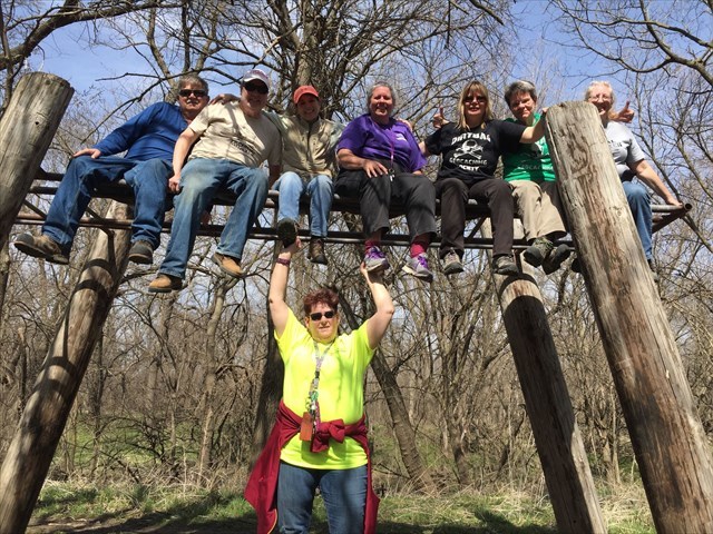
I ended up walking a little mile or so loop and finding a series of geocaches called the Witch of the Woods. This series was about a supposed with who lived in these woods and preyed on children. You had to find 4 shrines to various children that went missing in order to get parts of the coordinates for the final. Tossed in the middle of these geocaches was a an odd D/T rated cache called upper body strength (D/T=5/4). I would have rated this cache a 1.5/4.5, but then I have no problem pulling myself up on some monkey bars and finding the rather obvious nano cache on top. Others might have more difficulty and right as I was coming down from finding this cache a group of cachers showed up with a collapsible ladder and proceeded to have a merry old time climbing up and taking a big group photo. They were a friendly lot and we talked for a bit until we found out we knew some of the same geocachers, they knew the some of the TVG cachers pretty well including Diggin up Bones, BlackDot and QuarterMaster. It was fun to chat about the geocaching scene down in oak Ridge for a bit. In general, all the geocachers I ran into were very friendly and up for chatting, and I ran into geocachers all over the place. I did not run into any at the final for the Witch of the Woods though. This turned out to be a really cool final cache, with a sort of field puzzle where you had to find the right key out of a chain of 50 keys to unlock the container. Took me a while but I persisted.
Cachers I met at GC3XXTH, Upper Body Strength

After a few hours out, I headed back to the hotel to get ready for the competition, stopping only briefly to pick up a quick dinner consisting of a footlong black forest subway sandwhich. I only ate half though, because it’s no fun running on a full stomach, and then geared up for the night competition.

Friday, April 6, 2018

Fugads vs Dehydration

Some of the worst/scariest geocaching adventures I have had were due to dehydration. Well... dehydration and my often foolish/ambitious decisions to chase one too many geocache. Back in 2011 I got severely dehydrated on on particular outing in the Organ Mountains, linking up a bunch of different peaks and grabbing a bunch of geocaches along my way. I knew these mountains well, knew how difficult they are to get into, and how quickly one can run out of water... but I still went out. I ran out of water at the very top of the last peak that was my goal for the day... and then I had at least 3 hours to get back to my vehicle, in the hot afternoon sun. Unsurprisingly, I got badly dehydrated, to the point of nausea and dizziness.  It was not fun, and even a little scary. In my view, dehydration is the most real hazard of geocaching and hiking in the desert southwest. Finding water is basically out of the question... you either bring enough for your trip, or you suffer. After that trip, I was usually much better at gauging how much water to bring, only getting mildly dehyrdated over all my adventures in the following years. And dehydration as seemed like less of an issue up here in Santa Fe where I am living now, especially on the long hikes in the national forests, where there is almost always several reliable streams flowing cold clear mountain water.

My hike yesterday was a kick in the butt reminder that sometimes I still get into trouble with dehydration. It was my off-friday from work, the kid were in school, my wife at work and I had the day to myself to do whatever adventure I could think of. I had my eyes on a hike just south of Bandelier NP, up a desert peak called St. Peter's Dome. There were a handful of geocaches along a remote section of trail that I was targeting and I thought I'd tackle them as a trail run. I figured the total distance of my run would be around 12 miles, tough but doable for me. I had my standard running camelback which holds about 24 oz of water, and usually gets me through 4 hours of hiking/running pretty well. The first sign that things would be more difficult than expected where when I got to the Dome Rd, the first dirt road off the paved roads in Cochiti Pueblo. Last time I was here (previous summer) the road was open to traffic. Not today, a locked gate blocked the road and a sign stating the road was closed to prevent road degradation was what I was met with. So the first decision I had to make was... do I continue on with my plan anyways? Checking my map, it looked like I would have an additional 3 miles of running to reach my planned trailhead. That would add an extra 6 miles to my overall run, not an insignificant amount. And this is where I probably should have thought harder about what I was getting myself into... but I didn't and decided to go for it. I have been doing a fair amount of running recently, although usually only 1-1.5 hour runs... and was feeling pretty good about what I could handle. I figured I could fly up and down the 3 miles of road, and it wouldn't add that much to my overall trip. That turned out not to be true.
Early in the run at Sanchez canyon, still feeling good

Actually, the jog up the road wasn't bad. This was when I was at my freshest, and despite the steady climb (XXX elevation gain) I was feeling pretty good about the it. I grabbed my first geocache,GC5TVKK ,and kept going on the actual dome trail. The sign at the trailhead said the Dome was 6 miles, and at this point I was feeling pretty good about getting there and back. After a little over a mile on the trail I came across another geocache at a small waterfall where there was a bit of water flowing. The water actually surfaced just before going over the edge of the waterfall, so I took mental note that this would be a good water source on my return, "just in case" I ran out. I scored another geocache here Through Fault of Fire, which was placed a year ago and still hadn't been found. Always a good feeling to get one of those. AS I kept going up the trail, the trail started getting fainter and harder to follow. It eventually turned up a canyon towards Cerro Picacho and once in the canyon became impossible to find. I slowed down a lot here, not just because the trail was hard to find, but also because I was climbing up the side of the mountain now and it was hard to jog. I was still making pretty good time though and arrived at my next two caches on Cerro Picacho which took me off the trail and up the steep slope of this ancient volcano. The actual St. Peter's Dome trail skirts around Cerro Picacho, but of course I had to get the geocaches, GCTYQH and GC5JF8R. The first one actually took me quite a while to find because the coordinates were on a rock out-cropping with a tall cliff, and I expended a lot of effort searching around the bottom of the cliff, when it turned out the cache was on top. This cache was a good old one though, and well stocked with toys. I left a nice entry in the logbook and made the steep climb up to GC5JF8R, which was at the summit. Nice views and all, and I saw a small herd of dear, but now I had to descend down to the saddle to the north. And I was starting to feel real tired.
FTF in sanchez cayon

The trail between Cerro Picacho and St. Peter's dome was a bit easier to follow once I got back on it. It also wasn't too steep, and would have made for good jogging, but I was only able to jog portions of it. I was beginning to feel the effects of my earlier exertions. Still, I was feeling pretty good and simply hiked when I couldn't jog. I ran up and tagged St. Peter's Dome and ate the small snack I had with me, a handful of dried apricots and salted almonds. It was at this point that I realized my water was actually pretty low. The weight of my camelback was a little deceptive since I had a few extra items stuffed in there for my run. I also realized that it was more than 6 miles to the top of St. Peter's dome, since the trail ended nearly a mile below the summit, and the trail sign didn't account for this extra distance/climb. But I was already out there and there was only one more geocache to find, GC29EDH, which was another mile further away on mostly level trail. Really, alarm bells should have been ringing. I was almost out of water and I had a long way to get back, but I forged on jogging over to this last and final cache on Boundary Peak, a cool little volcanic mound overlooking the Bandelier NP. Looking at my maps, I noticed that there was a trail that went down into the national park from here, and that connected to a trail which would take me back to my original trailhead. I considered that the trail up Cerro Picacho was hard to follow and that this one would be easier and better maintained, being in the national park... and that it also looked to be about the same distance back. So off I went. Looking back now, it's hard to say if this was a bad idea. It certainly added more mileage to my route, despite looking like it was about the same as what I had come up. The trails were in decent shape though, but the mileage... oh that mileage... became a problem.
St. Peter's Dome Lookout Tower

Looking out over Bandelier NP from the Boundary Peak

I jogged down the boundary peak trail to the first junction within the park, Turkey Springs trail. I ran out of water here. The sign said Turkey Springs was 2.5 miles away and if I could have kept jogging I probably would have made it pretty quickly. But I had been rationing my water for a while already and despite only just running out of water, I was already on the edge of dehydration. To add to this, I had no idea what to expect at Turkey Springs, but the water source that I knew of was at Sanchez Falls, where I scored an earlier FTF, and it looked like that water was at least 5 miles away. I slowed down... a lot. Running along a trail dehydrates you much faster, and since it wasn't too warm out and the sky was a bit overcast, I figured I'd do better just hiking and trying to kept myself from sweating much. Even so, the signs of dehydration all started appearing, cotton mouth, dry skin, slight wooziness... and I was slowing down.  To make matters a little worse, I was getting anxious about when I would get back to my car and Santa Fe. I hadn't thought I would be out so long and was planning on picking up my kids after school, and then resting up before my orchestra rehearsal alter that night. Looking at the time and my slow progress it seriously looked like I would not make it back in time for either. Luckily, my new GPSr allows me to contact my wife, which I did. I tried to convey as much as possible in a few sentences, telling her not to worry and that I was taking care of myself. Which I guess I was... but there isn't a whole lot one can do int this situation. Worse case scenario is I would have to stop altogether and call for help... which I could have done, but I wasn't too that point yet.

I pushed on and finally made it to Turkey Springs which to my great joy, was a nice bubbling creek of cold water. Normally I would never drink from a stream without filtering, but this was an emergency so I drank up and refilled my camelback. I was honestly expecting to bounce back after getting rehydrated... but that didn't happen. As I force marched myself down the trail again, I still was slow and woozy. I threw up two times along this section of trail, losing all my snack from earlier and also some of the water I had just consumed. It puzzles me why my body would react to dehydration by vomiting. I mean, wouldn't it react to my need of fluids by not expelling a bunch of them from my stomach? Maybe it has something to do with the rehydration process, as I only vomited after I was able tog et some fluids back into my body? I don't know the answer, but I did know that I was weak and going slow. I did not "bounce back" as hoped, and it continued to be a struggle to force myself to continue down the trail. But at least I had water now. I sipped and hiked, sipped and hiked... and eventually made it to Sanchez falls, where I was able to drink some more nice cool water from the stream there. I still had a good amount of water in my camelback, and it wasn't easy to fill without getting tons of algae in my camelback, so I decided not to refill here (mistake again). I still had 5 miles to go to get back to my car. It was getting later in the afternoon, but I felt that I would make it out. My wife had responded that she could get the kids, and I still had a glimmer of hope that I'd make my orchestra rehearsal.

That glimmer faded as I continued along the last 5 miles. I was still slow, and it hurt to walk. I am pretty sure my body was telling me to take an hour long rest, but I was afraid if I stopped moving my legs would seize up entirely and I would have to call for help. So I kept on walking. It was agonizing. To help keep my mind off how much I ached, I started listening to podcasts on my phone. This helped take my mind off of my misery a little bit. Funnily enough, one of the podcasts I listened too was about geocaching burn-out. Will this dehydration experience lead me to geocaching burnout? I think not, but I am definitely going to learn a bit about my hikes before heading out. This one turned into a much bigger fiasco/adventure than I had bargained for.

With two miles left to go, I ran out of water again. Should have refilled at Sanchez falls. At this point though I was less dehydrated from before, having consumed a decent amount of water. But I still ached something fierce, and my body was telling me to stop. Stop I didn't and eventually, my car came into sight, and I felt some relief that it was all over. The time was 5:45 pm. My 5 hour, 12 mile trail run had turned into a 9.5 hour, 24 mile fiasco. But it was done. I fired off an email to my orchestra music director, letting him know I would not be playing tonight. I was in no condition for that at the moment. I let my wife know I was out and heading to the closest convenience store to get some electrolytes and more fluid. And most importantly, I could let my body relax. No more slogging for now.  Definitely some lessons learned on this adventure.

Just before reaching my car... dehydrated and exhausted and in oh so much pain, but safe at last.


Saturday, March 31, 2018

Getting Ready for MOGA 2018


MOGA 2018 is only a few weeks ago and I feel like I'm much less prepared for this year's competition. That said, I did go on a training run out in the Bajada, a desert region west of Santa Fe which contains a big geo-art that makes for decent training for MOGA. MOGA competitions are about running around from cache to cache to see how many you can get in a 2.5 hour period, and this geoart lends itself to this. Of course, the MOGA comps are usually cross-country, and this particular geo-art is along back-roads, which makes it not ideal for training. But it still allows me to get into a groove of running and searching, running and searching. As a side benefit, Geocaching.com is doing a promotion right now called Planetary Pursuit, which is trying to motivate cachers to find a bunch of different caches for a few week period in order to unlock digital souvenirs. Getting all the souvenirs was going to be tough for me with my current rate of geocaching, but since Mystery caches give you extra points, this geo-art was my best shot at completing the Planetary Pursuit challenge.

I had excellent calm cool weather for a run through the desert, and it was just as crowded as I like... I ran into only one other vehicle along my whole run! My chosen route was just a portion of the whole geo-art, but one that I thought would be about the right amount of time, ~2.5 hrs. Pretty quickly I got into a groove.... running the 550 ft between each geocache, and then stopping to make the find. For the most part, each geocache was a quick find, but a few gave me some trouble, and three I just couldn't find. The amount of work that the CO put into making all these containers, and listings is mind boggling. Every cache is a bison drilled and epoxied into a rock. And usually this made them easy to find. But occasionally GZ was strewn with a bunch of similar rocks, and these ones were tough. Also, as with a MOGA competition, I didn't want to linger at any one location for too long at any hide, giving myself only 5 minutes to look. The three that I didn't find also had some other DNFs so it's possible they may be missing or displaced from their GZ.. or maybe I just missed the hide.

The biggest benefit for me on this run was getting used to my new GPSr as far as MOGA race mode is concerned. My new GPSr is a great unit, (Garmin In Reach) but it is not meant to be a geocaching device. My old Garmin 60csx was great for geocaching and competitions and I worry a bit that my new device will be something of a hinderance. It doesn't treat waypoints as geocaches, with an easy toggle between found and not found. Instead, all waypoints are just that... and it isn't easy to go to one, and then immediately select the next closest to go after. I was having to figure out a method for selecting my next target, all while jogging down the road to not waste time. I eventually figured out a decent method, but because of certain aspects of the devices interface, I ended up missing two geocaches along my route because I thought they were something else. This kind of mistake could mean losing out in a MOGA competition... so it's something I'll have to be extra careful about. I'm glad I had some time to figure out these issues before the comp though.

Friday, January 5, 2018

2017 LCP NM Back-Country Champion... maybe

How did that happen? To be fair, every year I've geocached in New Mexico I have chased this leaderboard, and in 2013 I was actually quite close. I was in the top spot that year but Wolf11469 had some late-year finds that bumped him ahead of me. The next year we moved out of state, so LCP was not something I could partake in, but we came back in 2016 and I jumped right back into the game (see this blog post). That year I was only able to climb to 6th in the NM back-country leaderboard, but considering I was only in the state for half the year, this wasn't a bad showing. I hit some pretty high point caches, some really lonely ones that had gone unfound for quite some time.

This year, aside from January where I was near the top due to a fun geocache outing on new Year's day where I found a handful of fairly lonely caches, I was mostly in the 3rd to 5th rank position. The geocachers that were always ahead of me were Sandpig, sywy, budabeli and occasionally others were ahead as well. I had pretty much resigned myself to this ranking, but when I checked just the other day, some recent point activity between the eladers had cause d them to drop, and me to rise, and 'lo and behold, I was in the top spot!

2017 is over now, but the final point tally isn't final until January 15th, so I will need to wait until then to see if I retain this position. I know I didn't have any lonely finds in late December that are still waiting to be added to my score. I just have to hope that the other contenders do not have any. You can be sure, on January 15th, i will be checking back at lonelycache.com to see if I made it as the Top Back Country Geocacher in NM in 2017!

Monday, January 1, 2018

Winter caching in upsate New york

We were in upstate New York for the holidays this year. The last time we were here was in 2014, and I was anxious to check on my two geocache hides. Theoretically, I can ask family to check on these for me, but I stupidly hid both of them with high terrain ratings (3.5 and greater) and with my in-laws getting up there in years, neither location is really one I would be comfortable having them check for me anymore. But they know where they are now, and have contacts and I suppose if there was an issue, I could rope them into finding someone to help me out. But so far there hasn't been much need for this. Both caches, GC4348N and GC43EVW are pretty rural, off any main highway, and somewhat tricky puzzle caches. So the amount of traffic they get is extremely low. The two caches have a combined find count of 11 over 5 years, so if either of them gets a find in any given year, I'm pretty happy. And given this low find rate, maintenance needs are low. So I was surprised when I checked on GC4348N and found it missing. Would someone really have climbed down under this unassuming bridge and taken this little plastic container? I think it more likely that flood waters carried the cache away, my in-laws reported that the bridge was closed due to flooding last summer, and this very likely would account for the missing cache. Lucky for me, no one had searched for the cache since this flood, so I was able to get a new container in place. Hopefully, it can go another 5 years without any problem.
GC43EVW in good shape

Somewhat of a spoiler pic...

In general, I haven't had to worry about winter geocaching woes. Here in New Mexico, where we live now, we only get snow up in the high mountains, so you can simply find caches at the lower elevations that are free from snow. Not so in upstate New York. When I arrived, it was sleeting and there was already a foot of snow covering the ground. The sleet turned into a hard layer of ice, and then got covered by another foot of snow. This makes finding any geocache placed on the ground extremely difficult, if not impossible. Digging in the snow, even in the exact location where the cache is, may still be fruitless. Winter is definitely not the best time to find geocaches up here. But that doesn't mean it can't be done, it just means it requires all that much more effort.

I decided to test my winter caching abilities while out performing maintenance on my two geocaches. The first cache I went after,GC4QV91 , had a hint indicating it was at the base of a tree. At GZ there were several trees that it could have been and I dug around three of them before finding the frozen plastic container. It was actually not too difficult, but very very cold. unfortunately, the log had previously been a wet mushy pulp of peper, and was now a solid frozen block of un-signable ice. I guess that's another reason caching in winter is tough. Any wet log is bound to be un-usable.
How does one sign this?

My next two caches I stopped to find on my way back to the in-laws' I also found, although one of them was a nice dry magnetic key holder under a town bell. Definitely a winter friendly hide, although I had to post-hole through 20" of snow to reach the bell. Maybe winter caching isn't as hard as I thought it would be.

Rather than simply go after the random local hides that were around, I wanted to do something a bit more my style. A hike up a mountain with a rewarding viewt. An area that particularly caught by eye was Old Forge, a touristy Adirondack town nestled among lakes and mountain ridges. There are a number of short day hikes up to rocky ridge-tops most having a geocache on them. And it is only an hour's drive from our home-base. The only thing that gave me some pause was the intense cold-snap that hit right after Christmas. The window thermometer was down in the -20F to -30F range every morning and daily highs didn't even reach 0F. This is not what most people would consider reasonable hiking weather, and indeed my in-laws (and wife) thought I was crazy to even consider it. But I strongly believe, there is not bad weather for going outside, only bad clothing. As long as I was prepared, I could handle the cold. I had a good layering system, and warm winter jacket. I bought some chemical hand and toe warmers to keep the extremities from freezing and headed off early one morning to hike up Bald Mountain, one of the most popular day hikes in the Old Forge area.

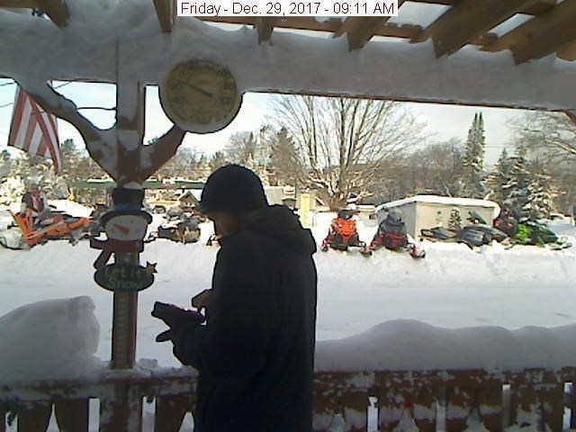
I left fairly early in the morning, with temps showing -25F outside. I stopped in Old Forge to find the Webcam cache there, GC3C3A. This proved to be more challenging than I thought it would be since the posted coordinates for the webcam are actually about a mile from where the webcam is. Simply going to the coordinates (as I did) gets you no-where, you need to look up the name of the Hotel where the webcam is located and navigate there. I was a bit miffed about this, seems the CO should be able to correct this fairly easily, but no matter. I finally got to the right place and waited around for the webcam to refresh, taking this "charming picture".

Temps were only -11F at this point, the day sure was warming up! Webcam found (only my second one ever!) I made my way over to the Bald Mountain trailhead to start my hike. I was a little worried that parking would be a problem. Earlier in the week, I had dragged the family over to Pixley falls but we couldn't actually go in to see the waterfalls because the run-off and parking area were not plowed, and there wasn't enough shoulder on the side of the highway to park. I was hoping this wouldn't be the case at Bald Mountain, since it might mean having to park further away somewhere and hike a bunch of extra distance along the side of a road. Luckily, the parking area was nicely plowed, and I was the first person to show up to hike the peak this morning.

I had brought with me two pairs of snow-shoes, one large and one small. My thinking was that if the trail was covered in deep snow, the large pair would be handy. But as I got to the trail register, I found that the trail was already very well packed. So well in fact, that snowshoes were hardly necessary at all. I strapped on the smaller pair anyways, because I knew that near the summit I would be going off trail to find the geocaches there, and then the snow-shoes would be useful.
Good info to have while hiking in extreme weather (cold)

Well packed trail

Starting out at the trailhead

The hike up was beautiful, and predictably cold. My nose and cheeks stung from the bitter cold, but the rest of me stayed nice and toasty. In less than an hour I was at the summit enjoying amazing views of the frozen lakes and snow covered peaks.
Near the summit

There are two geocaches up on the summit and I intended to find them both. The first, an earthcache called Bald Mountain Balancing Rock, was pretty easy to get to, but harder to answer all the geology questions due to the snow cover. Some of the questions asked you to compare the balanced rock to the surrounding rock, but everything was covered in snow. I did the best I could, and the questions I couldn't immediately answer in the location I ended up doing a bit of online research to get answers.
Bald Mountain balanced Rock


The other geocache was an older ammo can cache. This one worried me in that I would have to dig through deep snow to find it. The fresh snow on the summit was about 16-20" deep, and it could have been really difficult to search the ground. Luckily, given the hint, and the hide location, I was able to find the cache quickly and easily. I left a set of chemical hand and foot warmers, and grabbed a pathtag.
GC4PA7D in good shape

Finally, I spent a bit of time at the Fire Tower on the summit, taking in the amazing views all around. I had the whole place to myself and reveled in the glory of being out on a frozen mountaintop all by myself. Took me back to my college days, when I would go winter hiking/climbing in the North East. It felt good to know I could still enjoy such activities.
Rondaxe Fire Tower

Panorama from within tower
 
Panorama of 3rd Lake

Since I had taken off my snow-shoes to climb the tower, I left them off for the descent hike. They really weren't needed at all for the packed trail. I passed a few other hikers starting up the trail as I got close to the trailhead, proving that I was not the only crazy person to be out hiking in sub-zero temperatures. But then, the well packed trail told me that as well. I do believe that hiking Bald Mountain in winter may be preferable to summer/fall, judging from the stories I've heard about hundreds/thousands of people hiking up every day. Having the mountain all to yourself is worth the chill.

After my nice hike, I met up with the rest of the family in Old Forge for lunch and to peruse the "Adirondack's Most General Store". I couldn't resist but order the "Mountain maniac" sandwhich from the restaurant. I would have loved to do more hiking in the area, and more geocaching, but I'll have to save that for another trip. I know we'll be back visiting family again, and now I can strike off to this relatively close area for adventurous hiking.

 I barely cached at all the rest of our trip except for finding a cache on 12/31/17 and one on 1/1/18 so that I could earn the souvenirs given out on these days. I dragged my father in-law with me to find a cache on 12/31 and we got pretty lucky to find, GC4M19Q, one of the closest geocaches around our area. The cache listing indicated it should be winter friendly, but it also indicated that it could be buried by snow banks since it was in a guard rail. Turns out it was the latter, but I dug into the snow bank at just the right spot to find the geocache right away. On the first of the New Year, we left the in-laws to head back home, driving to Syracuse to catch our flight early the next morning. I had solved a puzzle cache near the Syracuse airport for just this evening, and after checking into the airport hotel, but before returning our rental car, I made a quick trip out to look for GC2F628. I was hoping this would be an easy LPC cache, given the location of the hide in a strip-mall area, but it turned out to be in a small wooded section adjacent to a tire shop. Luckily, in Syracuse there was only a few inches of snow on the ground and after a bit of brushing away snow, I found the cache. A nice geocaching end to a wonderful trip in new York. And a promising geocaching start to the new year.
First cache of 2018!

Sunday, December 17, 2017

Frustrated by Gates in the Jemez

Not for the first time, I've found myself on a geocache inspired drive through rugged and remote back-country. This latest trip was in the Jemez mountains, taking back-roads between Espanola, the Cladarea, and Abiquiu. One of Santa Fe's local cachers recently placed a bunch of new caches on a back road out there, leading up to the high point of the Jemez mountains, Chicoma. These caches, and the few peaks along the route were my main goal, but there was one very lonely cache on dirt road connecting the road near Chicoma to Abiquiu that I also was interested in getting, mainly for the Lonely Cache Points. Why not right? I'll tell you why not, that road was a rocky, rutted mess. Twice I used the maps I had both in the car, and on my GPSr to find ways to get off that road and to other parts of the mountain range, but both times I failed. The first time the road ended up at the edge of a plateau. My map showed a zig-zag path down this steep slope, but there was no passable road to be found. The second time I ran into a locked gate. I bet that road would have eventually gotten me off of the Polvedera plateau, but what can i do about a locked gate? Not much.
So what I originally thought was going to ba a half-day trip driving up into the mountains, turned into a full-day rough trail ride. Luckily, i had the presence of mind to fill up my gas tank in Espanola before tackling the mountain roads.

This part of the Jemez is pretty inaccessible. Sure there are some roads that can get you back out there, but they are slow going. There is also a lot of exploring that can be done out here though. Not hiking trails, just old logging roads, mining camps, remote volcanic peaks... I'll have to come back out some time to see what i can find.
Clara Peak Lookout GC7AYAE


Near the top of Chicoma Mountain GC7DZ1Z


Great views at GC3RGCK

The Carnales Memorial, GC3QKXX

Herd of elk on the way to Abiquiu

My dusty TB

A very lonely cache deep in the Jemez on the Polvedera Mesa, GC3RGEB