Friday, October 2, 2015

The Legend Of Petty John

I don't remember exactly how I became aware of this cache, but at some point I stumbled across The Legend Of Petty John and immediately wanted to go try it out. I've done a few caches that are near caves, or some kind of man made tunnel, but never something that was a true caving experience. This cave looked pretty serious and I would have to find another cacher interested, and despite dropping the name a couple times to various local cachers, no one really seemed that interested. There was a couple from Kentucky that were pretty interested, and I crossed my fingers that they would contact me. But an opportunity came even sooner that I just couldn't pass up. I was at a recent geocaching event celebrating Wascally Wabbit's 10K milestone and ran into GISpuma, a local Oak Ridge cacher that I knew was into caving. I had briefly talked to her at a meeting a year ago, and we talked about caving a bit, but I hadn't crossed paths with her since, and I probably didn't know about the Petty John cache. She must not have known about it either, because when I mentioned wanting to do this caving cache to her, she was immediately interested and was even already planning on being in the area. I begged my wife to take off work on a Friday, and plans were made to go on a caving expedition to Pigeon Mountain, Georgia.

Now I have a lot of gear, from climbing to backpacking and hiking. but caving is not something I've done much of. Despite having been on a Technical Search and Rescue Team in New Mexico (one that specialized in cave rescue as well as cliffs and stuff), I really never got into any caves. Well, I did go into Carlsbad Caverns once, but that was so tourist friendly that it didn't feel like Caving at all. That's not to say I didn't think I could handle some pretty challenging stuff. I can scramble over rocks with the best of them, and I'm pretty comfortable descending and ascending ropes. After talking with GISpuma a bit more though, we decided to not do any sections of the cave requiring rope work. We'd just explore what could be done without technical gear. I did go out and buy a cheap pair of kneepads though, because from what I could find on the internet, we would be in a lot of low passages.

I got most of my information about the cave from a website called CAPS, where there were detailed maps of various portions of the cave. The cave system looked pretty darn big to me, with a dozen different offshoots and some very tricky looking passages. As the day of our trip drew nearer, I got more and more excited, and also a little worried about what I was getting into. You can find all sorts of commentary on the internet about cool cave trips, and also accidents that have happened there. And I was beginning to get a sense that serious Cavers shied away from this cave and considered it trashy even. To make matters worse, a huge weather system, nay, hurricane, was just off the Carolina coast and was bringing a good amount of rain to the area at about the same time we'd be going underground. I didn't have a good sense of if this would make the cave more dangerous, but my gut was that it would. After a few email exchanges with GISpuma, we decided to still go for it, but to be extra cautious about passages with water in them. This meant not trying to get to the popular waterfall feature in the cave. I was ok with that.

On the day of our trip, I got up early and drove in the dark and rain into Georgia. Aside from the airport, this was my first time visiting the state, which was kind of cool. I left extra early to allow myself some time to explore Rock Town, which not only is a very cool climbing spot, but also contains one of the oldest geocaches in the area, GC76, placed back on October 2000. Ok, so it is only 15 years old, it's not like an amazing time capsule or anything, but geocachers get somewhat excited about finding "old" geocaches like this one. And I am not immune to that. I had a nice 2 mile trail run in the rain, then made my way back to the parking coordinates for Petty John Cave. GISpuma pulled up a little after 1030am and we were soon kitted up and ready to go down into the ground.
Blurry "Before" Picture at the entrance
I was probably way overpacked for this adventure. They say to bring at least 3 sources of light, I had 6, and also extra batteries. I had enough food (well, calories is a better term) to keep going for 48 hours. I had maps, cameras, water, an emergency blanket... I even brought my GPSr along even though it would be mostly useless in the cave. I simply brought it so that we could check our solution to the geocache puzzle while still underground near the clues. GISpuma on the other hand was going light. She had a small backpack (half the size of mine) and disposable Tyvek coveralls. I was already feeling like a rookie, but then, I suppose I was. After the obligatory entrance shot, we went down, and immediately met our first cave dweller, a Cave Salamander.
Entrance Greeter
The entrance Room, as the map calls it, has a very high ceiling and is broad as well, but does not have a nice even floor. Instead there are jumbles of fallen rocks and pits to negotiate. I learned that Cavers call the jumbled masses of boulders "breakdown" or "break" for short, and that often finding a way down through the break is what leads to other passageways.This was indeed the case for us on our way to our first destination, the Pancake Squeeze. Once we made it down through the break, we got a bit confused about where we were. We were looking for specific clues for the geocache, which had descriptions of natural features we should see in certain places, but the clues weren't quite matching up nto the map we had. We went through what we thought was the pancake squeeze, only to then find the Z-bend passage on the wrong side of the outlet room, suggesting that instead we had been in the Flat Room.


While not knowing where we were exactly caused us to slow down, and take out the map frequently for consultation, it also added to the sense of exploration, not really knowing what we were going to come up to next. We ended up squeezing our way through the Z-bends and came out on what appeared to be the outlet of the pancake squeeze. The clues for the geocache were not making any sense, and we debated crawling back through the pancake squeeze right then. But the lure of more cave further on won out, we opted to continue exploring for a while and try to figure out the geocache clues on our way back.
GISpuma in the Z-bends
While heading south along an easy passage I learned a bit more about what makes a Caver versus a Spelunker. I had previously used the terms synonymously, but apparently that is a big mistake. A Caver is someone who takes caving seriously, usually a member of a local Caving Group, and follows a Code of Ethics while in cave systems. Aside from what seems like basic common sense ideas, like leave no trash and don't disturb any animals, it also includes not touching any cave formations, not defacing the walls and never taking anything out of the cave. Spelunkers on the other hand are just people that get excited about going into caves but don't really know to treat them with care and respect. They are more just going in for an adventure, are often not well prepared, leave spray-paint markings on walls (sometimes as graffiti, but also for directions so as not to get lost) and also a fair amount of trash.
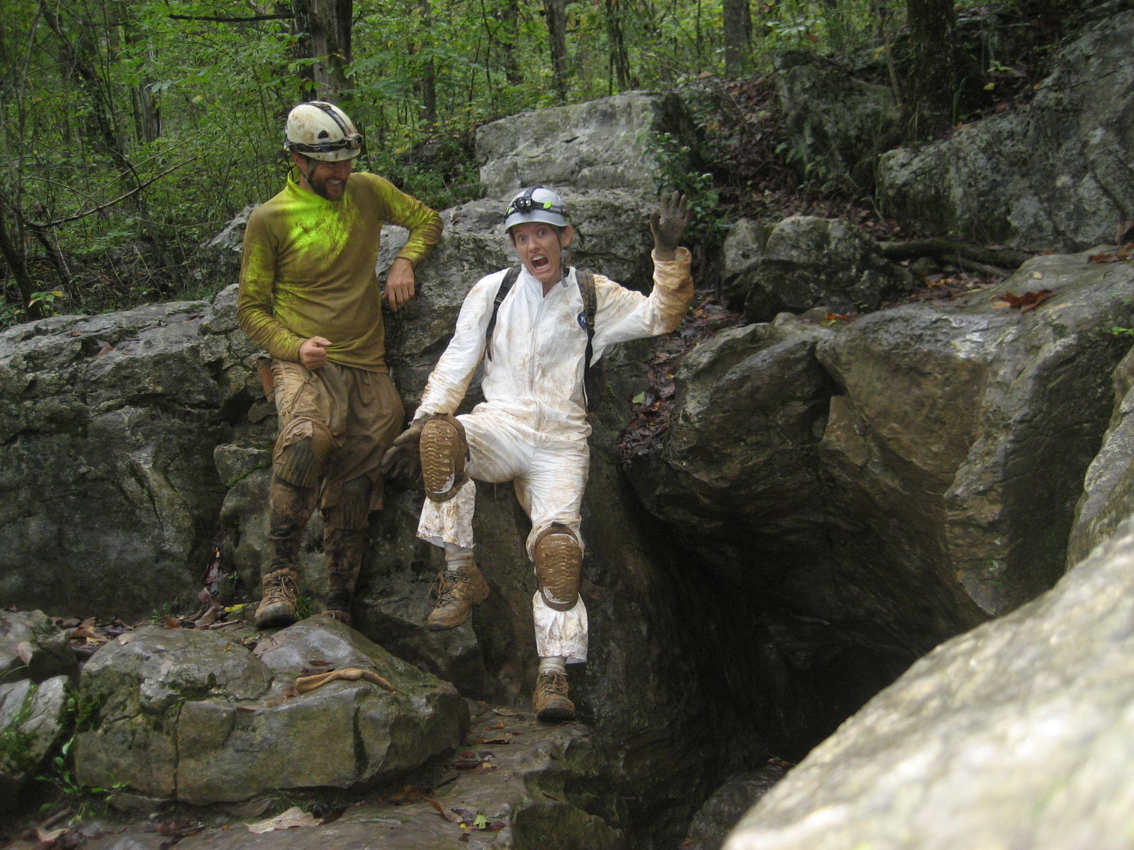
Caver or Spelunker?
It is easy to see how Cavers would look down on Spelunkers, because Spelunkers includes the people that deface formations, leave trash (and human waste!) all over the cave, and are more likely to get hurt or killed. Then again, there are probably Spelunkers that behave well, but you'd never hear about them. You do see the effects that the less respectful Spelunkers leave behind. We saw a good amount of trash everywhere in the cave, as well as broken cave formations, and spray paint. I thought some of the spray paint arrows were actually pretty useful, but GISpuma assured me there are better ways to mark your route without defacing the walls.
Broken stalactite
We almost hit a dead end before reaching the Raccoon Room. We could see on our map where it was, but just couldn't see how we were supposed to get there. The room before the Raccoon Room was very tall and had a lot of deep pits and break-down in it. There were several ropes leading down beneath the breakdown but we think those led to the Stream Passage and aside from not wanting to go there because of flooding concerns, none of the descent ropes looked very safe. We finally found a very tight squeeze high up on the west wall that led us to a narrow crawl and over to the connecting passageway to the Raccoon room. The funny thing was, we saw a lot of signs that people came through the Raccoon room pretty frequently, but it just didn't seem likely that they came in the way we found. There must have been a better way, but we just didn't know where it was.

Once we got to the Raccoon Room, the cave passages beyond were much easier to follow. Not as many side branches, or confusing junctions, just muddy crawl-ways and cool cave formations.
One of the nice formations past the Raccoon Room
Nice Formation of a small pool. I especially like the drip captured

The only real challenging passage was a short crawl called the Freeway, which was only slightly taller than a foot high, and very muddy. But it was still easier than the Z-Bends which we had done earlier, since it was mostly linear. Another interesting room we came to was the Bridge Room which had a very deep pit in it where we could hear the stream below. The Bridge Room was also a junction with some passages that led north and would make a potential loop route. However, we decided to press on to the Over 'N Under Room, which was only a short ways beyond.
GISpuma on the far side of the pit of the Bridge Rom
Cave formations in passage leading up to the Over 'N Under Room
It was 2:30 by the time we reached the Over N' Under Room, which seemed like a good time to turn around. Not that I really wanted to turn around. GISpuma had mentioned that it was really easy to completely lose track of time in a cave, and I can see why. All the normal cues about passage of time are gone, and the amount of passages to explore is very tempting. From the Over 'N Under Room there were passages leading to a waterfall, or to other far reaches of the cave system. But if we were to tackle much more, we would most certainly get back out very late, and I didn't want to do that, it would make my wife worry too much. And GISpuma was going to be going into Ellison Cave the next day, which is a pretty serious and exhausting cave involving multiple rope descents, some as long as 540'. There was no reason to push further other than this primal urge to keep on exploring.  It will have to be another day. The Over 'N Under Room seemed like a good turn around point too, since it held one of the cave's registers, at least one that is marked on the map. We opened it up to find that it only held one very soggy sheet of paper, an old cave map printout. A handful of signatures were on the sheet going back to April 2014, but I'm guessing that not many people bother to sign it. It isn't in good shape. But I added our names.
The Register at the Over 'N Under Room
Our return trip was quite a bit faster which is understandable because we knew where we were going now. We found the "easier" way that led into the Raccoon Room passage, a steep climb up and around some blocks and with high exposure and slippery mud. The way we found was tighter and not for everyone, but probably a whole lot less dangerous. We encountered a second cave salamander on our way back to the Pancake Squeeze, which I thought surprising since it is pretty far from the entrance. I thought that these salamanders lived in the "twilight" zone near cave entrances, but GISpuma told me that they can be found far from the entrance. They must be much better adapted to living in the dark than I thought they were.
How is this guy not covered in mud like us?
When we made it back to the Panacake Squeeze we went through it this time. It was very tight, but also wide, so it didn't feel as bad as the Z-bends. But then, I'm a relatively small guy, perhaps for someone larger they would be pretty constrictive.
GISpuma coming through the Pancake Squeeze
Once out of the Pancake Squeeze we went back to the Flat Room to try to verify the clues for the geocache. Kind of funny that going after this geocache was the "main purpose" of our expedition, but that it was treated as an afterthought to simply exploring the cave. Still, we wanted to make the find on the cache.
Myself coming out into the Flat Room, another belly crawl
After a bit of debate, and theorizing about what the CO was thinking, we finally settled on some answers for the geocache and computed the coordinates. I took out my GPSr and put the coords in, and they seemed reasonable, so out we went. We just had a short climb back up to the Entrance Room, then an easy walk back out of the cave.
POsing at one side of the Z-bends

Interesting floor ramp formation on the way up to the Entrance Room
We emerged into daylight a little past 4:30, after 5 1/2 hours in the cave. The rain had stopped, and the even the dull grey skies seemed impressively bright. And I must say, I can easily see how one catches the Caving bug. While we had explored a lot of this cave, there was so much more we hadn't explored, and I felt myself wanting to go on, and see what all the other rooms and passages are like. And there are oodles of caves in the area, many a lot closer to home. GISpuma was an excellent caving companion, and she hinted at trips to other, cleaner caves, that I could come on, maybe even with the kids (ones not as dangerous as this one). And I think I would be very excited to do so, even if there isn't a geocache to lure me there. But for now, I am just happy to have had this wonderful adventure.
How is GISpuma not completely covered in mud?


So after all that, did we even find the geocache? ....
You Bet!
Post Script: During the trip, GISpuma kept mentioning how she disliked getting wet and muddy, and I kind of poo-poo'ed her sentiments. I mean, we knew it was a muddy cave, why not just embrace the mud and grime and have fun. Well, there is a good practical reason to keep clean. The clean up is not only time consuming, but also very vital. This cave is known to harbor White Nose Syndrome, and not only do you need to clean the mud off of everything, you also need to do careful decontamination of all your equipment, at least if you think any of it will be used in other caves. I spent a few hours already cleaning off mud, and am still not even close to getting things cleaned up and decontaminated. GISpuma was wise indeed. Next, time, hopefully I will be a little wiser as well.

Tuesday, September 29, 2015

6 years abandoned


Ever wonder what a geocache looks like when it has been abandoned for 6 years? Well here's your chance to find out! After a nice long day hike in the Slickrock Wilderness, I decided to stop for a cache that has been archived for over 6 years now, called Tail of the Dragon. I learned about the existence of this cache when I found it's sister cache, Head of the Dragon a few months ago, which is still very much active. As I investigated what had become of Tail cache, I noted that the owner had archived the listing due to land management issues with the GSMNP, but no one had ever posted that the cache was in need of maintenance or even missing, and the owner didn't mention retrieving it either. That didn't mean that he hadn't retrieved it, but judging from the cache page, this cache was located in a slightly extreme location that not many people could even reach and I suspected that the ammo can was simply left there.

So after driving down the Dragon Road, I pulled over close to the coordinates for the cache and went about climbing the steep hill (more details about that in my log for the cache). Sure enough, the ammo can was there, mostly buried under pine duff but otherwise in great shape. I don't think the previous finders could have hidden it very well, it seemed to be almost out in the open, but so much the better for me.
A 6-years abandoned cache
I ended up retrieving the container and contacting the CO to see what he wanted to do with it. He wasn't that interested in getting it back to use himself, so I'm going to re-purpose it for one of my next hides, or maybe use it as a door-prize at my next event. The cache was pretty well stocked with goodies, and while slightly stale, nothing was in trash condition.
 It was a pretty awesome finish to my day, finding this old abandoned cache. Makes me want to hunt for more archived caches, I bet there are abandoned caches just waiting to be found.

Monday, September 28, 2015

The Fugads Wooden Nickle

In the course of 4 years of geocaching I've come across many cool signature items from other geocachers. But until now I haven't had one of my own. Introducing the Fugads Wooden nickle!
My wife made these for me just last week. Just another reason why she is the best woman in the world! the design is simple with a picture of me heading out towards the Organ mountains with all my climbing kit, and my geocaching name of course. I've already started dropping them in geocaches around the area, so look for one near you today!

How many boots and shoes does it take to go 1000 miles?

What is it about big round numbers that make us want to celebrate achievement of some kind of milestone? I once wrote a log at this cache about how milestones can be just about anything. From the cache size, to the species, to the D/T rating, to how many in a certain month, or on a certain day, or... just about anything. Numbers are everywhere in this game, and in life in general and when you want to go looking for them, they surround you. But that doesn't change the fact that numbers that trails a lots of zeros from them are especially favored. And for geocachers on of the favorites of these is 1000. Usually this means 1000 finds, and is a goal set by many cachers to reach. Once they reach it, it is not uncommon for the local group of geocaching friends to celebrate the achievement with an event, and the presentation of a golden ammo can, or some other such ridiculous geocaching trophy. My own 1000th find was at a particularly challenging challenge cache which had got me thinking about numbers of a different sort, from the outset of my geocaching addition. The cache, 100,000 Ft Challenge, involved keeping track of the elevation gain on geocaching hikes you have done, and trying to accumulate 100,000 ft of elevation gain. This is quite a lot, and the cache remains elusive, with only 15 finds over 7 years. It was also a challenge I was determined to meet, and I diligently kept track of all my hikes. After nearly two years of hiking and geocaching, I finally crested 100,000ft, and it was a wonderful feeling to go and find the challenge cache and add my name to the short list of other serious geohikers.

Elevation gain wasn't the only thing I kept track of though, I also recorded miles traveled since it just made sense to me. And I happened to notice that I was getting close to passing the 1000 mile mark back in July when I passed the 200,000' elevation mark. A few months later, and with a nice 12.8 mile hike in a wilderness area in North Carolina, I finally passed 1000 miles!
My book keeping has some quirks, making it not so straightforward to determine how many distinct hikes/runs this encompasses, but it is roughly 230 different instances. My average outing is 4.71 miles in length. My maximum outing was 26.5 miles on a huge wilderness hike with my friend Birddroppings to find Reed's Peak. The minimum is a bit wonky since I typically do not record a hike or run that is less than a mile unless it had over 200' elevation gain, in which case I did because that was one of the criteria for the 100,000' challenge cache. Basically, if it is a relatively short walk, I don't feel like it is worth recording. This probably cuts out hundreds of additional miles, since out of the nearly 3000 caches I've found, only 230 of those "trips" qualified as hikes/runs, so the majority were quick grabs with little significant mileage, and all those add up I'm sure. But to me, they just didn't seem worth keeping track of. By this methodology, 0.3 miles on a cache called Navajo Bill Hill, was my shortest hike, and it just barely popped over 200' elevation gain, making it short but steep. There were quite a few short but steep caches in New Mexico, the topography lends itself well towards placing caches on random high hilltops out in the desert.

In the course of hiking and running over 1000 miles, I've gone through 3 sets of running shoes and 4 pairs of hiking boots. But in all those miles, there is hardly an injury to be found. The worst thing I can recall that happened while out hiking for caches was getting severely dehydrated in the Organ Mountains. Hopefully, I can keep this safety record up and garner many more 1000s of miles. Here's to getting out and having fun!

Sunday, September 27, 2015

Slickrock Creek: Hiking into one of North Carolina's Lonely Wildernesses


A little over a month ago I hid a letterbox/hybrid cache along the Dragon Road, Hwy 129, and the cache was promptly attacked by a bear. I ended up taking the family up to Fontana Lake the next weekend and replaced the cache with the same type of container, an empty peanut butter jar. I kind of knew that the container might be what is attracting the bears in the first place, but I didn't have a nother container handy at the moment and figured this time it would be ok. Well, a few weeks later I get a note from a letterboxer that the cache was hijacked by an animal again, probably a bear, and this time the stamp and logbook went missing along with the peanut butter container. So not only was I going to have to replace the container, but now I needed to recarve the stamp and make a new logbook (can't used simple ruled notepads since the lines don't look good for people's stamps). It took a bit of time, but I finally got around to carving up a new stamp and I purchased a decent container that hopefully will be of no interest to bears or any wildlife. Now I just needed an excuse to ride the dragon again.

My excuse wasn't much of one, there is great hiking in Cherokee National Forest and it was a simple matter of finding a hike that looked awesome and picking a day to go when my wife could stay home with the kids. The hike I took an interest in was in the Slickrock Wilderness, also known as the Joyce-Kilmer/Slickrock wilderness. There are two geocaches deep in the wilderness that rarely get found and looked to promise a good day, crossing streams and splashing in waterfalls. I was fully planning on going solo, since my regular hiking partner, Jake, wasn't free this weekend, but then thought I'd see if I could find some geocachers interested in coming with me. Two particular geocachers came to mind, Lullabye4U and Kaput360. I had met them a few times before and they were always very friendly. They also create some of the areas coolest gadget caches, and I knew we'd have loads of good geocaching discussions if we went hiking together. But most importantly, they are good hikers. I often see their names on the hiking geocaches in the Cumberlands, and they were the first (and so far only) finders of my geocaches on the Obed River section of the CT, which is a pretty hefty 14 mile thru-hike. If they could handle that they would surely be interested in this hike wouldn't they?

To be fair, I wasn't exactly sure how long this hike was going to be. My plan was to take trail #42 from the Tapoco trailhead, pass by Lower Falls and GC13HVN at about 3 miles. From there the Slickrock Trail (#42) continues on eventually reaching Wildcat Falls and GC1EM4V which would be our final destination and turn around point. but after a bunch of online searching I couldn't quite figure out how much further along Wildcat Falls was. It looked to be about 4 miles beyond Lower Falls, but with all the meanderings of the stream (and trail?) I was worried it could be more like 6 miles. If it was indeed that far, our roundtrip hike would be 18 miles long, which was pretty ambitious, but still within what I thought would be doable, at least for myself. But would Lullabye and Kaput think so? I contacted them and they seemed eager to give it a try, so I packed up for a long day of hiking, including headlamp, extra flashlights, water purifier and emergency blankets. If we ended up getting caught out. However long the hike was going to be, I wanted to be prepared.

I left the house at 6am and drove solo up the Dragon Road. The plan was to meet at the trailhead at 8am, but I made good enough time that I decided to stop at my Letterbox Cache on the Dragon Road. The letterboxer who found it last had cleaned it up nicely, there were no toys or broken containers laying about, and it looked to be in decent shape. I added my new stamp/logbook container and dropped off a few travel bugs (one with a dragon theme), picked out all the broken pieces of tupperware that remained, and the cache was good to go. Then I was off the meet Lullabye and Kaput. I pulled into the trailhead parking area about 10 minutes early, and they were already there waiting for me. It took me a few minutes to get my kit together, but we were soon off, hitting the trailhead right at 8 o'clock sharp.
Kaput and Lullabye4u at the start of the day
The trail started off nice and wide, a few hundred feet above the lake below and to our right, but soon started climbing up the embankment and getting narrower. At point it got very narrow and looked to be almost entirely eroding away into the steep hillside, but there was always enough tread for us to make steady progress. After a mile or so, it turned up the Slickrock creek drainage and away from the Tennessee River, or Cheoah lake or whatever it is you call that body of water. The river here has been dammed in so many places I get confused as to whether you call it a river or a leak, and if it is a lake, what name it gets. Kaput always just called it "the lake", so maybe I'll stick with that. Once the trail moved up to follow slickrock creek, it immediately earned its namesake, with several sections of slick wet rock that we had to negotiate over. Definitely not the easiest trail around, but not too bad overall. The best part was that since the trail stayed along the creek, we never had much of a steep incline to contend with. Just a gentle grade up the ravine.

We made decent time, and were soon at our first destination, the geocache called Slickrock. I don't often geocache in with a group of people, but when I do, we usually just comb out and whoever finds the cache first just yells something out, usually "found it!". But I had heard of other ways to cache as a group that sounded kind of fun. One method of group geocaching is to use an old childs game called Huckle Buckle Beanstalk. To play this way, when one person finds the geocache, they keep looking for a while, then yell out "huckle buckle beanstalk" and wait in a pre-determined location. The remaining players continue to look until everyone has found the cache. The idea is to allow each cacher a chance to find the container on their own, and get the "full experience". I think I heard about it on the geocaching forums, but we had a small group and Lullabye and Kaput seemed game to try it out.

As luck would have it, I found the geocache first, and after continuing to pretend to search for a bit, I yelled out that I had found it and went to the gravel bar beneath the waterfall to wait for them to make the find. I took my shoes off and waded into the ice cold water, took tons of pictures and ate an apple as the others kept searching. Eventually, I started yelling out hints until they made the find. I thought this game was pretty fun and was grinning ear-to-ear. Lullabye and Kaput were not so amused, as they were sweating over their search while I leisurely relaxed in front of the waterfall. I think some disparaging words were spoken, and it was quickly settled that we wouldn't be playing this "huckeberry foolishness" at our next cache. "But I thought it was fun" I exclaimed. "That's because you found it first," Lullaby retorted. Touché.
Playing Huckle Buckle Beanstalk. Yes, it's a blooper picture!
The waterfall, known as Lower Falls, that we were at was exceedingly nice. I was sorely tempted to take a swim, but resisted the urge knowing that we still had many miles of hiking ahead of us, and not wanting to do all of that in wet shorts.
The trail beyond lower falls involved half a dozen or so stream crossings. The creek wasn't too high, but it was high enough to make the crossings challenging. And the creek also lived up to its name, with the rocks being very slick. Nevertheless, I nimbly hopped across boulders and managed to keep my boots dry at each of the crossings. This eventually became somewhat infuriating for Lullaby and Kaput, who both ended up with wet boots. Sasha was only one who didn't seem to mind getting her feet wet, and was happy to trot across the streams, looking at us like we were crazy.
Getting boots wet

Negotiating one of the many crossings

One of the more creative stream crossings
We didn't see much wildlife along our hike, but I feel like I often don't when I'm hiking with Sasha. She tends to make a lot of noise and alert wildlife to our presence pretty well. Lullabye did spot a nice sized red spotted newt in it's eft stage though.
We also saw a bunch of neat mushroom specimens. Both Lullabye and Kaput seemed pretty interested in mushrooms, and I did my best to recall what little I knew about some of the types of mushrooms we found. There were some very nice bollette species, and of course, many Russalas. Also some bright orange chantrelle like mushrooms growing in the moss along the stream. I'll have to dig up my Mushrooms Demystified book, perhaps even loan it out to them.
We finally reached Wildcat Falls at around 1pm and settled in for a late lunch. I took a quick swim beforehand and the water was icy and refreshing. The pool underneath the waterfall was deep and clear, with a few early autumn leaves floating peacefully around in the eddy currents. The waterfall has a couple different tiers and each with fun bathing opportunities. Alas, it simply was not hot enough outside to merit a long swim, and I was soon very chilled. Lullabye and Kaput looked like they briefly entertained the idea of hopping in as well, but thought the better of it once they were up to their knees.
Wildcat Falls
We found the cache here pretty quickly, despite a not having great satellite coverage and a mostly useless hint of "laurel/boulders" in an area festooned with laurel and boulders. I made the find again, ad now Lullabye and Kaput seem to think I am a super-finder. Really I'm not! I just got lucky this time around. This cache has only been visited 4 times in 7 years, a nice lonely cache to be sure. Man, the geocachers around here don't know what they are missing! The waterfall is gorgeous and remote, pristine and peaceful. What's not to like? I traded out some of the swag, swapping an emergency blanket for the sewing kit, and leaving one of my new signature tokens. I filled up a page in the logbook with some musings, then we rehid the cache well, so that the next adventurous geocachers will have something to enjoy other than the stunning natural scenery.

Group shot in front of the falls
Upper tier
Looking down at the main plunge pool
Lullabye and Kaput in the photo nook
Negotiating the slick rock

A third teir of waterfall about 200' upstream that looked to have an amazing cliff jumping spot. It was heard to get a good picture of this waterfall, but it was just as nice as those below.
As is often the case, the hike back seemed to go faster than the way in. I continued to hop gracefully across the stream crossings as Lullaby and Kaput grumbled at me and got their feet wet yet again. They had changed into dry socks earlier, but those were now wet also. We happily chatted about hiking and geocaching while we hiked and I learned that they are relatively new hikers, getting into it in the last year or so because of geocaching. I think I may have talked them into getting some new gear, like a lightweight water purifier which I had brought with me so we wouldn't have to carry so much water, and good hiking socks. I put in a plug for my favorite hiking sock company, Darn Tough Socks, of Vermont. I can't tout having good socks enough, if you are seriously hiking a lot, you need to take care of your feet, and good socks really do matter. Even more so than good shoes I think. But that's my product placement spiel for now.


It also sounds like Lullabye and Kaput have one heck of a cool geocache series they are working on. The amount of work and thought they put into their caches is incredible and I'm looking forward to seeing the new caches when they come out. As geocachers go, they are pretty new to the game, having started a little over a year ago. And already they have over 1000 finds, and in places around the country and world.  It was quite a treat to be able to go hiking with them and I feel pretty confident that they will play a big role in keeping this game fun for this area for years to come.

Despite making great time on the return trip, we were still all getting tired, especially Sasha who would fall asleep if we stopped for more than 60 seconds. To shorten our return hike, we consulted a trailmap I had with me and decided to take a slightly different trail that would shave maybe a mile off our hike. Trail #45, or the Ike Branch Trail, bypassed Lower Falls and went up over a ridge line before descending down to "the lake" along a steep streambed. It would mean more elevation gain, but promised to get us home a bit quicker, so we went for it. The trail started off fairly steep, and also had quite a bit of treefall. But after several tree crossings, ti leveled off to a reasonable incline and was clear and easy going. Lullabye and Kaput swapped out for dry socks again to try to stave off blisters on their wet feet, and then it was just a steady march up over the ridge and then down to the lake. Turns out trail #45 did save us 0.8 of a mile, but at a cost of 400ft elevation gain. Plus it was much hotter and drier getting away from the stream system. I drained the rest of my water quickly, and was actually sweating pretty hard for the first time all day. Oh how I would have liked to jump into the Lower Falls then, but we had bypassed the falls entirely.

We stumbled back to our cars right at 5:40pm. Tired but still in pretty good spirits. Fresh clothes awaited us in the cars. I asked Lullabye and Kaput if they were going to stop at any caches on the way back, half thinking that perhaps they would want to see my Dragon themed letterbox, but they had only one thought in mind, going straight home and relaxing. Me, I still had a little bit in me... but that's a story for another post.
End of day shot
Some parting thoughts: It was a pleasure to hike with Lullaby and Kaput, I hope we get together for more hikes in the future. They are funny, friendly and excited geocachers and they also really appreaciate a good hike. Seems like these traits aren't so common with most geocachers, so I am grateful that we could get together for this hike. The hike ended up clocking in at 12.8 miles, with about 1500' elevation gain throughout the day. A long hike, but not terribly long in my mind. We also didn't see a single other hiker, even though there were several cars at the trailhead. Makes me want to tackle some more wilderness hikes in this area. There are some more trails and remote and lonely caches out here just waiting for cachers like us to go find them. And if it was up to me, we'd be right back out here next weekend, enjoying another fine fall day.